You are here: Home > Network List > TA - USArray Transportable Network (new EarthScope stations) Stations List
> Station L29M Grand Valley Creek, YT, CAN > Earthquake Result Viewer
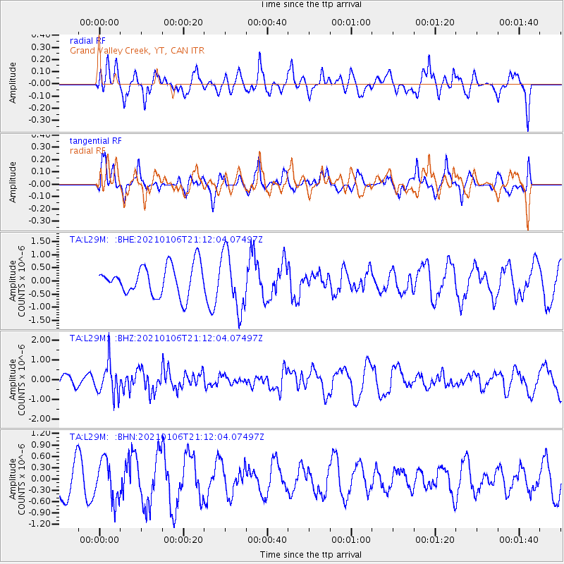
L29M Grand Valley Creek, YT, CAN - Earthquake Result Viewer
*The percent match for this event was below the threshold and hence no stack was calculated.
| Earthquake location: |
Minahassa Peninsula, Sulawesi |
| Earthquake latitude/longitude: |
0.0/122.9 |
| Earthquake time(UTC): |
2021/01/06 (006) 20:59:35 GMT |
| Earthquake Depth: |
157 km |
| Earthquake Magnitude: |
6.1 mww |
| Earthquake Catalog/Contributor: |
NEIC PDE/us |
|
| Network: |
TA USArray Transportable Network (new EarthScope stations) |
| Station: |
L29M Grand Valley Creek, YT, CAN |
| Lat/Lon: |
63.11 N/138.13 W |
| Elevation: |
918 m |
|
| Distance: |
94.0 deg |
| Az: |
26.763 deg |
| Baz: |
277.985 deg |
| Ray Param: |
$rayparam |
*The percent match for this event was below the threshold and hence was not used in the summary stack. |
|
| Radial Match: |
51.58969 % |
| Radial Bump: |
400 |
| Transverse Match: |
49.794796 % |
| Transverse Bump: |
349 |
| SOD ConfigId: |
23341671 |
| Insert Time: |
2021-01-20 22:08:41.172 +0000 |
| GWidth: |
2.5 |
| Max Bumps: |
400 |
| Tol: |
0.001 |
|
Signal To Noise
| Channel | StoN | STA | LTA |
| TA:L29M: :BHZ:20210106T21:12:04.07497Z | 3.0649314 | 8.472595E-7 | 2.7643668E-7 |
| TA:L29M: :BHN:20210106T21:12:04.07497Z | 0.8160916 | 5.224144E-7 | 6.401418E-7 |
| TA:L29M: :BHE:20210106T21:12:04.07497Z | 1.9753423 | 1.1141726E-6 | 5.640403E-7 |
| Arrivals |
| Ps | |
| PpPs | |
| PsPs/PpSs | |


