You are here: Home > Network List > GE - GEOFON Stations List
> Station JER GII Station Jerusalem, Israel > Earthquake Result Viewer
JER GII Station Jerusalem, Israel - Earthquake Result Viewer
| Earthquake location: |
E. Russia-N.E. China Border Reg. |
| Earthquake latitude/longitude: |
43.8/130.7 |
| Earthquake time(UTC): |
2002/06/28 (179) 17:19:30 GMT |
| Earthquake Depth: |
566 km |
| Earthquake Magnitude: |
6.7 MB, 7.3 MW, 7.3 MW |
| Earthquake Catalog/Contributor: |
WHDF/NEIC |
|
| Network: |
GE GEOFON |
| Station: |
JER GII Station Jerusalem, Israel |
| Lat/Lon: |
31.77 N/35.20 E |
| Elevation: |
770 m |
|
| Distance: |
72.4 deg |
| Az: |
297.195 deg |
| Baz: |
49.179 deg |
| Ray Param: |
0.051805764 |
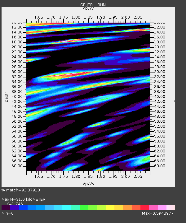
| Estimated Moho Depth: |
31.0 km |
| Estimated Crust Vp/Vs: |
1.75 |
| Assumed Crust Vp: |
6.391 km/s |
| Estimated Crust Vs: |
3.662 km/s |
| Estimated Crust Poisson's Ratio: |
0.26 |
|
| Radial Match: |
93.87913 % |
| Radial Bump: |
400 |
| Transverse Match: |
92.32749 % |
| Transverse Bump: |
400 |
| SOD ConfigId: |
20082 |
| Insert Time: |
2010-03-09 04:33:30.434 +0000 |
| GWidth: |
2.5 |
| Max Bumps: |
400 |
| Tol: |
0.001 |
|

Signal To Noise
| Channel | StoN | STA | LTA |
| GE:JER: :BHN:20020628T17:29:28.587017Z | 14.985401 | 1.7142107E-6 | 1.1439205E-7 |
| GE:JER: :BHE:20020628T17:29:28.587017Z | 11.074579 | 2.0084647E-6 | 1.813581E-7 |
| GE:JER: :BHZ:20020628T17:29:28.587017Z | 31.61459 | 8.9373525E-6 | 2.826971E-7 |
| Arrivals |
| Ps | 3.7 SECOND |
| PpPs | 13 SECOND |
| PsPs/PpSs | 17 SECOND |


