You are here: Home > Network List > GE - GEOFON Stations List
> Station JER GII Station Jerusalem, Israel > Earthquake Result Viewer
JER GII Station Jerusalem, Israel - Earthquake Result Viewer
| Earthquake location: |
Kuril Islands |
| Earthquake latitude/longitude: |
44.3/150.0 |
| Earthquake time(UTC): |
2002/10/19 (292) 12:09:05 GMT |
| Earthquake Depth: |
33 km |
| Earthquake Magnitude: |
5.4 MB, 6.2 MS, 6.4 MW, 6.1 MW |
| Earthquake Catalog/Contributor: |
WHDF/NEIC |
|
| Network: |
GE GEOFON |
| Station: |
JER GII Station Jerusalem, Israel |
| Lat/Lon: |
31.77 N/35.20 E |
| Elevation: |
770 m |
|
| Distance: |
83.8 deg |
| Az: |
308.922 deg |
| Baz: |
40.989 deg |
| Ray Param: |
0.045906868 |
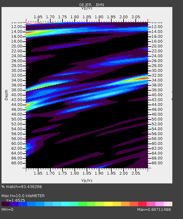
| Estimated Moho Depth: |
10.0 km |
| Estimated Crust Vp/Vs: |
1.65 |
| Assumed Crust Vp: |
6.391 km/s |
| Estimated Crust Vs: |
3.867 km/s |
| Estimated Crust Poisson's Ratio: |
0.21 |
|
| Radial Match: |
93.438286 % |
| Radial Bump: |
400 |
| Transverse Match: |
86.33808 % |
| Transverse Bump: |
400 |
| SOD ConfigId: |
4714 |
| Insert Time: |
2010-03-09 04:33:43.508 +0000 |
| GWidth: |
2.5 |
| Max Bumps: |
400 |
| Tol: |
0.001 |
|

Signal To Noise
| Channel | StoN | STA | LTA |
| GE:JER: :BHN:20021019T12:21:00.072993Z | 1.4425589 | 1.4921133E-7 | 1.0343518E-7 |
| GE:JER: :BHE:20021019T12:21:00.049006Z | 0.9756053 | 1.4779039E-7 | 1.5148584E-7 |
| GE:JER: :BHZ:20021019T12:21:00.072993Z | 4.069933 | 6.896778E-7 | 1.6945678E-7 |
| Arrivals |
| Ps | 1.0 SECOND |
| PpPs | 4.0 SECOND |
| PsPs/PpSs | 5.1 SECOND |


