You are here: Home > Network List > GE - GEOFON Stations List
> Station JER GII Station Jerusalem, Israel > Earthquake Result Viewer
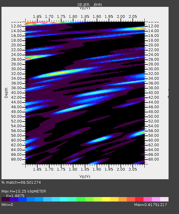
JER GII Station Jerusalem, Israel - Earthquake Result Viewer
| Earthquake location: |
Primor'ye, Russia |
| Earthquake latitude/longitude: |
45.5/136.7 |
| Earthquake time(UTC): |
2002/02/01 (032) 21:55:20 GMT |
| Earthquake Depth: |
356 km |
| Earthquake Magnitude: |
6.2 MB, 6.0 MW, 5.9 MW |
| Earthquake Catalog/Contributor: |
WHDF/NEIC |
|
| Network: |
GE GEOFON |
| Station: |
JER GII Station Jerusalem, Israel |
| Lat/Lon: |
31.77 N/35.20 E |
| Elevation: |
770 m |
|
| Distance: |
75.4 deg |
| Az: |
300.399 deg |
| Baz: |
45.452 deg |
| Ray Param: |
0.05069205 |
| Estimated Moho Depth: |
10.25 km |
| Estimated Crust Vp/Vs: |
1.69 |
| Assumed Crust Vp: |
6.391 km/s |
| Estimated Crust Vs: |
3.787 km/s |
| Estimated Crust Poisson's Ratio: |
0.23 |
|
| Radial Match: |
86.501274 % |
| Radial Bump: |
400 |
| Transverse Match: |
86.11696 % |
| Transverse Bump: |
400 |
| SOD ConfigId: |
4714 |
| Insert Time: |
2010-03-09 04:33:48.290 +0000 |
| GWidth: |
2.5 |
| Max Bumps: |
400 |
| Tol: |
0.001 |
|

Signal To Noise
| Channel | StoN | STA | LTA |
| GE:JER: :BHN:20020201T22:05:55.307017Z | 4.2950263 | 5.091488E-7 | 1.1854381E-7 |
| GE:JER: :BHE:20020201T22:05:55.307017Z | 4.681818 | 1.9089992E-8 | 4.077474E-9 |
| GE:JER: :BHZ:20020201T22:05:55.307017Z | 28.006672 | 3.142116E-6 | 1.1219169E-7 |
| Arrivals |
| Ps | 1.1 SECOND |
| PpPs | 4.2 SECOND |
| PsPs/PpSs | 5.3 SECOND |


