You are here: Home > Network List > GE - GEOFON Stations List
> Station JER GII Station Jerusalem, Israel > Earthquake Result Viewer
JER GII Station Jerusalem, Israel - Earthquake Result Viewer
| Earthquake location: |
Taiwan |
| Earthquake latitude/longitude: |
23.5/121.6 |
| Earthquake time(UTC): |
2003/06/10 (161) 08:40:30 GMT |
| Earthquake Depth: |
44 km |
| Earthquake Magnitude: |
5.8 MB, 5.7 MS, 6.0 MW, 5.9 MW |
| Earthquake Catalog/Contributor: |
WHDF/NEIC |
|
| Network: |
GE GEOFON |
| Station: |
JER GII Station Jerusalem, Israel |
| Lat/Lon: |
31.77 N/35.20 E |
| Elevation: |
770 m |
|
| Distance: |
75.1 deg |
| Az: |
298.415 deg |
| Baz: |
71.415 deg |
| Ray Param: |
0.051796235 |
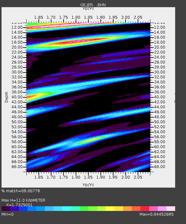
| Estimated Moho Depth: |
11.0 km |
| Estimated Crust Vp/Vs: |
1.73 |
| Assumed Crust Vp: |
6.391 km/s |
| Estimated Crust Vs: |
3.689 km/s |
| Estimated Crust Poisson's Ratio: |
0.25 |
|
| Radial Match: |
89.88779 % |
| Radial Bump: |
400 |
| Transverse Match: |
77.74027 % |
| Transverse Bump: |
400 |
| SOD ConfigId: |
4714 |
| Insert Time: |
2010-03-09 04:33:57.803 +0000 |
| GWidth: |
2.5 |
| Max Bumps: |
400 |
| Tol: |
0.001 |
|

Signal To Noise
| Channel | StoN | STA | LTA |
| GE:JER: :BHN:20030610T08:51:37.38603Z | 1.0257431 | 1.4256572E-7 | 1.3898774E-7 |
| GE:JER: :BHE:20030610T08:51:37.410017Z | 2.0775123 | 3.3144346E-7 | 1.5953863E-7 |
| GE:JER: :BHZ:20030610T08:51:37.410017Z | 7.5416265 | 1.164977E-6 | 1.5447291E-7 |
| Arrivals |
| Ps | 1.3 SECOND |
| PpPs | 4.6 SECOND |
| PsPs/PpSs | 5.9 SECOND |


