You are here: Home > Network List > GS - US Geological Survey Networks Stations List
> Station MT02 Nevada Ogden Rd, Helena Natl Forest, Montana, USA > Earthquake Result Viewer
MT02 Nevada Ogden Rd, Helena Natl Forest, Montana, USA - Earthquake Result Viewer
| Earthquake location: |
South Of Fiji Islands |
| Earthquake latitude/longitude: |
-23.7/-176.9 |
| Earthquake time(UTC): |
2017/09/26 (269) 04:20:00 GMT |
| Earthquake Depth: |
98 km |
| Earthquake Magnitude: |
6.4 mww |
| Earthquake Catalog/Contributor: |
NEIC PDE/us |
|
| Network: |
GS US Geological Survey Networks |
| Station: |
MT02 Nevada Ogden Rd, Helena Natl Forest, Montana, USA |
| Lat/Lon: |
46.86 N/112.88 W |
| Elevation: |
1672 m |
|
| Distance: |
90.9 deg |
| Az: |
38.109 deg |
| Baz: |
235.517 deg |
| Ray Param: |
0.041621406 |
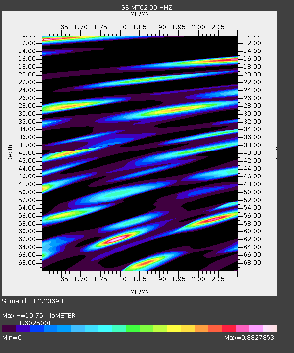
| Estimated Moho Depth: |
10.75 km |
| Estimated Crust Vp/Vs: |
1.60 |
| Assumed Crust Vp: |
6.353 km/s |
| Estimated Crust Vs: |
3.964 km/s |
| Estimated Crust Poisson's Ratio: |
0.18 |
|
| Radial Match: |
82.23693 % |
| Radial Bump: |
400 |
| Transverse Match: |
66.89908 % |
| Transverse Bump: |
400 |
| SOD ConfigId: |
2364251 |
| Insert Time: |
2017-10-10 04:22:18.757 +0000 |
| GWidth: |
2.5 |
| Max Bumps: |
400 |
| Tol: |
0.001 |
|

Signal To Noise
| Channel | StoN | STA | LTA |
| GS:MT02:00:HHZ:20170926T04:32:22.20397Z | 10.377261 | 8.158212E-7 | 7.861623E-8 |
| GS:MT02:00:HH1:20170926T04:32:22.20397Z | 3.108606 | 3.8605756E-7 | 1.2418992E-7 |
| GS:MT02:00:HH2:20170926T04:32:22.20397Z | 1.8150333 | 1.7656039E-7 | 9.727667E-8 |
| Arrivals |
| Ps | 1.0 SECOND |
| PpPs | 4.3 SECOND |
| PsPs/PpSs | 5.3 SECOND |


