You are here: Home > Network List > GS - US Geological Survey Networks Stations List
> Station OK031 S. Brethren Rd., Cushing, OK, USA > Earthquake Result Viewer
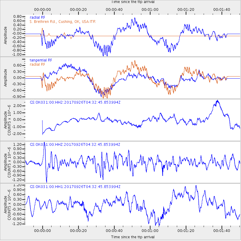
OK031 S. Brethren Rd., Cushing, OK, USA - Earthquake Result Viewer
*The percent match for this event was below the threshold and hence no stack was calculated.
| Earthquake location: |
South Of Fiji Islands |
| Earthquake latitude/longitude: |
-23.7/-176.9 |
| Earthquake time(UTC): |
2017/09/26 (269) 04:20:00 GMT |
| Earthquake Depth: |
98 km |
| Earthquake Magnitude: |
6.4 mww |
| Earthquake Catalog/Contributor: |
NEIC PDE/us |
|
| Network: |
GS US Geological Survey Networks |
| Station: |
OK031 S. Brethren Rd., Cushing, OK, USA |
| Lat/Lon: |
35.95 N/96.84 W |
| Elevation: |
290 m |
|
| Distance: |
96.1 deg |
| Az: |
53.494 deg |
| Baz: |
245.231 deg |
| Ray Param: |
$rayparam |
*The percent match for this event was below the threshold and hence was not used in the summary stack. |
|
| Radial Match: |
66.22923 % |
| Radial Bump: |
400 |
| Transverse Match: |
62.57579 % |
| Transverse Bump: |
400 |
| SOD ConfigId: |
2364251 |
| Insert Time: |
2017-10-10 04:22:25.240 +0000 |
| GWidth: |
2.5 |
| Max Bumps: |
400 |
| Tol: |
0.001 |
|
Signal To Noise
| Channel | StoN | STA | LTA |
| GS:OK031:00:HHZ:20170926T04:32:45.853994Z | 3.333006 | 6.7860134E-7 | 2.0360041E-7 |
| GS:OK031:00:HH1:20170926T04:32:45.853994Z | 0.52289367 | 2.0146979E-7 | 3.852978E-7 |
| GS:OK031:00:HH2:20170926T04:32:45.853994Z | 1.2252699 | 7.929571E-7 | 6.471693E-7 |
| Arrivals |
| Ps | |
| PpPs | |
| PsPs/PpSs | |


