You are here: Home > Network List > GT - Global Telemetered Seismograph Network (USAF/USGS) Stations List
> Station PLCA Paso Flores, Argentina > Earthquake Result Viewer
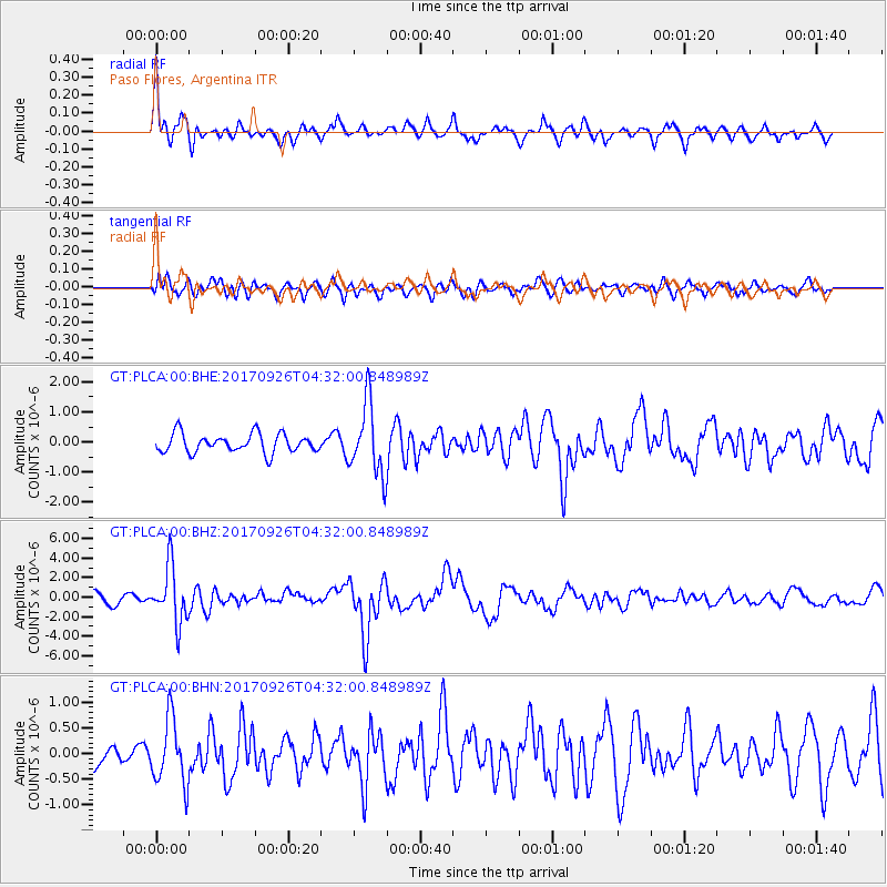
PLCA Paso Flores, Argentina - Earthquake Result Viewer
*The percent match for this event was below the threshold and hence no stack was calculated.
| Earthquake location: |
South Of Fiji Islands |
| Earthquake latitude/longitude: |
-23.7/-176.9 |
| Earthquake time(UTC): |
2017/09/26 (269) 04:20:00 GMT |
| Earthquake Depth: |
98 km |
| Earthquake Magnitude: |
6.4 mww |
| Earthquake Catalog/Contributor: |
NEIC PDE/us |
|
| Network: |
GT Global Telemetered Seismograph Network (USAF/USGS) |
| Station: |
PLCA Paso Flores, Argentina |
| Lat/Lon: |
40.73 S/70.55 W |
| Elevation: |
1050 m |
|
| Distance: |
86.4 deg |
| Az: |
133.069 deg |
| Baz: |
241.776 deg |
| Ray Param: |
$rayparam |
*The percent match for this event was below the threshold and hence was not used in the summary stack. |
|
| Radial Match: |
71.059525 % |
| Radial Bump: |
393 |
| Transverse Match: |
56.31804 % |
| Transverse Bump: |
400 |
| SOD ConfigId: |
2364251 |
| Insert Time: |
2017-10-10 04:22:42.156 +0000 |
| GWidth: |
2.5 |
| Max Bumps: |
400 |
| Tol: |
0.001 |
|
Signal To Noise
| Channel | StoN | STA | LTA |
| GT:PLCA:00:BHZ:20170926T04:32:00.848989Z | 3.769675 | 2.8628165E-6 | 7.5943325E-7 |
| GT:PLCA:00:BHN:20170926T04:32:00.848989Z | 1.4402589 | 6.3282357E-7 | 4.393818E-7 |
| GT:PLCA:00:BHE:20170926T04:32:00.848989Z | 3.7790565 | 1.1819899E-6 | 3.127738E-7 |
| Arrivals |
| Ps | |
| PpPs | |
| PsPs/PpSs | |


