You are here: Home > Network List > IU - Global Seismograph Network (GSN - IRIS/USGS) Stations List
> Station JOHN Johnston Island, USA > Earthquake Result Viewer
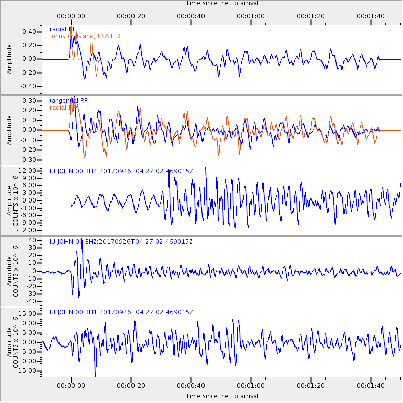
JOHN Johnston Island, USA - Earthquake Result Viewer
*The percent match for this event was below the threshold and hence no stack was calculated.
| Earthquake location: |
South Of Fiji Islands |
| Earthquake latitude/longitude: |
-23.7/-176.9 |
| Earthquake time(UTC): |
2017/09/26 (269) 04:20:00 GMT |
| Earthquake Depth: |
98 km |
| Earthquake Magnitude: |
6.4 mww |
| Earthquake Catalog/Contributor: |
NEIC PDE/us |
|
| Network: |
IU Global Seismograph Network (GSN - IRIS/USGS) |
| Station: |
JOHN Johnston Island, USA |
| Lat/Lon: |
16.73 N/169.53 W |
| Elevation: |
2.0 m |
|
| Distance: |
40.8 deg |
| Az: |
10.888 deg |
| Baz: |
190.409 deg |
| Ray Param: |
$rayparam |
*The percent match for this event was below the threshold and hence was not used in the summary stack. |
|
| Radial Match: |
72.2429 % |
| Radial Bump: |
400 |
| Transverse Match: |
76.487976 % |
| Transverse Bump: |
400 |
| SOD ConfigId: |
2364251 |
| Insert Time: |
2017-10-10 04:23:23.005 +0000 |
| GWidth: |
2.5 |
| Max Bumps: |
400 |
| Tol: |
0.001 |
|
Signal To Noise
| Channel | StoN | STA | LTA |
| IU:JOHN:00:BHZ:20170926T04:27:02.469015Z | 17.743166 | 1.9874025E-5 | 1.1200947E-6 |
| IU:JOHN:00:BH1:20170926T04:27:02.469015Z | 1.7874072 | 4.2398533E-6 | 2.372069E-6 |
| IU:JOHN:00:BH2:20170926T04:27:02.469015Z | 2.9611568 | 5.8592927E-6 | 1.9787174E-6 |
| Arrivals |
| Ps | |
| PpPs | |
| PsPs/PpSs | |


