You are here: Home > Network List > TA - USArray Transportable Network (new EarthScope stations) Stations List
> Station G16K Koyuk River, AK, USA > Earthquake Result Viewer
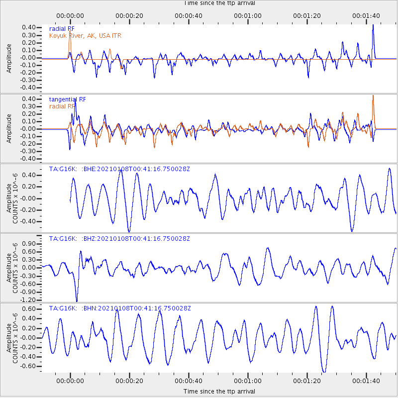
G16K Koyuk River, AK, USA - Earthquake Result Viewer
*The percent match for this event was below the threshold and hence no stack was calculated.
| Earthquake location: |
Kermadec Islands, New Zealand |
| Earthquake latitude/longitude: |
-29.4/-178.8 |
| Earthquake time(UTC): |
2021/01/08 (008) 00:28:49 GMT |
| Earthquake Depth: |
222 km |
| Earthquake Magnitude: |
6.3 mww |
| Earthquake Catalog/Contributor: |
NEIC PDE/us |
|
| Network: |
TA USArray Transportable Network (new EarthScope stations) |
| Station: |
G16K Koyuk River, AK, USA |
| Lat/Lon: |
65.39 N/162.35 W |
| Elevation: |
169 m |
|
| Distance: |
95.3 deg |
| Az: |
6.822 deg |
| Baz: |
194.332 deg |
| Ray Param: |
$rayparam |
*The percent match for this event was below the threshold and hence was not used in the summary stack. |
|
| Radial Match: |
58.86619 % |
| Radial Bump: |
330 |
| Transverse Match: |
77.78114 % |
| Transverse Bump: |
400 |
| SOD ConfigId: |
23341671 |
| Insert Time: |
2021-01-22 01:44:23.996 +0000 |
| GWidth: |
2.5 |
| Max Bumps: |
400 |
| Tol: |
0.001 |
|
Signal To Noise
| Channel | StoN | STA | LTA |
| TA:G16K: :BHZ:20210108T00:41:16.750028Z | 1.97621 | 5.124294E-7 | 2.5929904E-7 |
| TA:G16K: :BHN:20210108T00:41:16.750028Z | 1.1063173 | 1.5463367E-7 | 1.3977336E-7 |
| TA:G16K: :BHE:20210108T00:41:16.750028Z | 0.34540546 | 9.336299E-8 | 2.702997E-7 |
| Arrivals |
| Ps | |
| PpPs | |
| PsPs/PpSs | |


