You are here: Home > Network List > TA - USArray Transportable Network (new EarthScope stations) Stations List
> Station L15K Ungalak Mountain, AK, USA > Earthquake Result Viewer
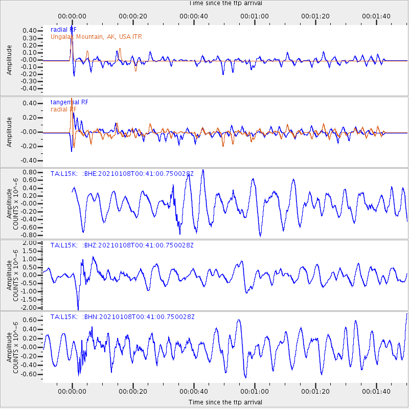
L15K Ungalak Mountain, AK, USA - Earthquake Result Viewer
*The percent match for this event was below the threshold and hence no stack was calculated.
| Earthquake location: |
Kermadec Islands, New Zealand |
| Earthquake latitude/longitude: |
-29.4/-178.8 |
| Earthquake time(UTC): |
2021/01/08 (008) 00:28:49 GMT |
| Earthquake Depth: |
222 km |
| Earthquake Magnitude: |
6.3 mww |
| Earthquake Catalog/Contributor: |
NEIC PDE/us |
|
| Network: |
TA USArray Transportable Network (new EarthScope stations) |
| Station: |
L15K Ungalak Mountain, AK, USA |
| Lat/Lon: |
61.68 N/161.49 W |
| Elevation: |
219 m |
|
| Distance: |
91.8 deg |
| Az: |
8.146 deg |
| Baz: |
195.025 deg |
| Ray Param: |
$rayparam |
*The percent match for this event was below the threshold and hence was not used in the summary stack. |
|
| Radial Match: |
57.348377 % |
| Radial Bump: |
400 |
| Transverse Match: |
41.79325 % |
| Transverse Bump: |
333 |
| SOD ConfigId: |
23341671 |
| Insert Time: |
2021-01-22 01:44:32.883 +0000 |
| GWidth: |
2.5 |
| Max Bumps: |
400 |
| Tol: |
0.001 |
|
Signal To Noise
| Channel | StoN | STA | LTA |
| TA:L15K: :BHZ:20210108T00:41:00.750028Z | 2.7057936 | 7.3144315E-7 | 2.7032482E-7 |
| TA:L15K: :BHN:20210108T00:41:00.750028Z | 1.1061654 | 2.4532963E-7 | 2.2178385E-7 |
| TA:L15K: :BHE:20210108T00:41:00.750028Z | 0.78647304 | 2.0683387E-7 | 2.6298915E-7 |
| Arrivals |
| Ps | |
| PpPs | |
| PsPs/PpSs | |


