You are here: Home > Network List > US - United States National Seismic Network Stations List
> Station DUG Dugway, Tooele County, Utah, USA > Earthquake Result Viewer
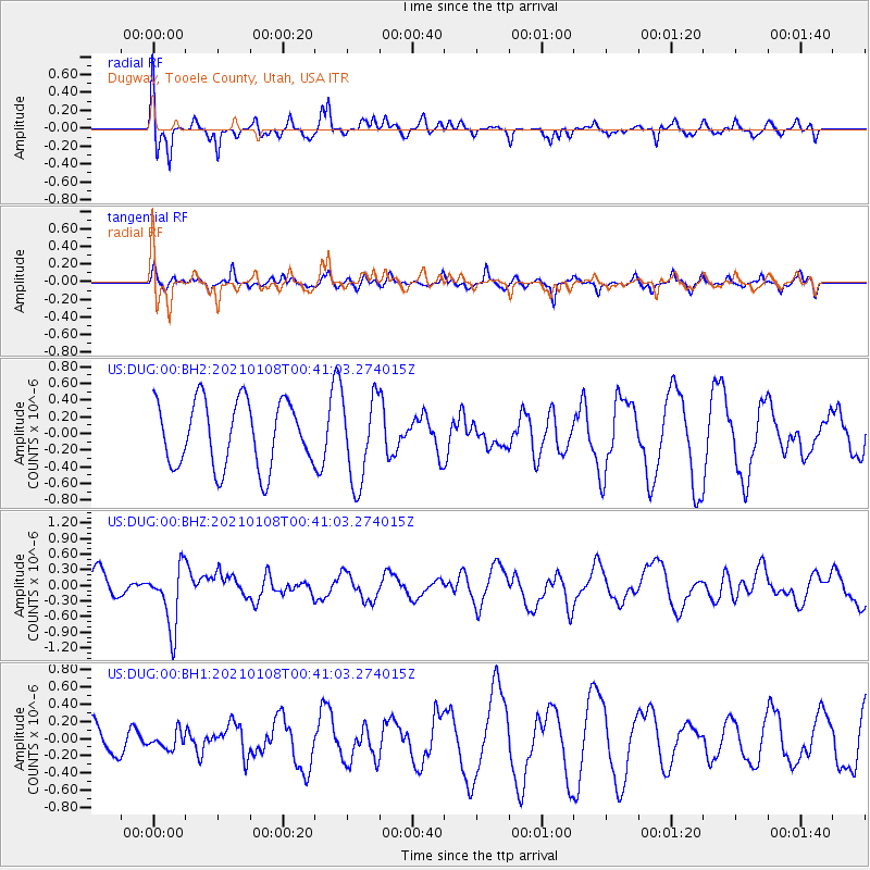
DUG Dugway, Tooele County, Utah, USA - Earthquake Result Viewer
*The percent match for this event was below the threshold and hence no stack was calculated.
| Earthquake location: |
Kermadec Islands, New Zealand |
| Earthquake latitude/longitude: |
-29.4/-178.8 |
| Earthquake time(UTC): |
2021/01/08 (008) 00:28:49 GMT |
| Earthquake Depth: |
222 km |
| Earthquake Magnitude: |
6.3 mww |
| Earthquake Catalog/Contributor: |
NEIC PDE/us |
|
| Network: |
US United States National Seismic Network |
| Station: |
DUG Dugway, Tooele County, Utah, USA |
| Lat/Lon: |
40.19 N/112.81 W |
| Elevation: |
1477 m |
|
| Distance: |
92.4 deg |
| Az: |
44.434 deg |
| Baz: |
232.892 deg |
| Ray Param: |
$rayparam |
*The percent match for this event was below the threshold and hence was not used in the summary stack. |
|
| Radial Match: |
70.66246 % |
| Radial Bump: |
400 |
| Transverse Match: |
41.995876 % |
| Transverse Bump: |
308 |
| SOD ConfigId: |
23341671 |
| Insert Time: |
2021-01-22 01:46:21.647 +0000 |
| GWidth: |
2.5 |
| Max Bumps: |
400 |
| Tol: |
0.001 |
|
Signal To Noise
| Channel | StoN | STA | LTA |
| US:DUG:00:BHZ:20210108T00:41:03.274015Z | 1.9332167 | 5.9360264E-7 | 3.0705436E-7 |
| US:DUG:00:BH1:20210108T00:41:03.274015Z | 0.58050233 | 9.714778E-8 | 1.6735125E-7 |
| US:DUG:00:BH2:20210108T00:41:03.274015Z | 1.3152118 | 5.178353E-7 | 3.937277E-7 |
| Arrivals |
| Ps | |
| PpPs | |
| PsPs/PpSs | |


