You are here: Home > Network List > UW - Pacific Northwest Regional Seismic Network Stations List
> Station HOOD Mt Hood Meadows, OR CREST BB SMO > Earthquake Result Viewer
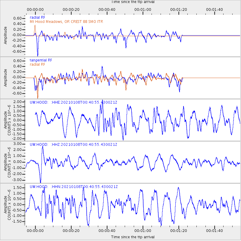
HOOD Mt Hood Meadows, OR CREST BB SMO - Earthquake Result Viewer
*The percent match for this event was below the threshold and hence no stack was calculated.
| Earthquake location: |
Kermadec Islands, New Zealand |
| Earthquake latitude/longitude: |
-29.4/-178.8 |
| Earthquake time(UTC): |
2021/01/08 (008) 00:28:49 GMT |
| Earthquake Depth: |
222 km |
| Earthquake Magnitude: |
6.3 mww |
| Earthquake Catalog/Contributor: |
NEIC PDE/us |
|
| Network: |
UW Pacific Northwest Regional Seismic Network |
| Station: |
HOOD Mt Hood Meadows, OR CREST BB SMO |
| Lat/Lon: |
45.32 N/121.65 W |
| Elevation: |
1520 m |
|
| Distance: |
90.7 deg |
| Az: |
36.332 deg |
| Baz: |
227.117 deg |
| Ray Param: |
$rayparam |
*The percent match for this event was below the threshold and hence was not used in the summary stack. |
|
| Radial Match: |
64.51742 % |
| Radial Bump: |
400 |
| Transverse Match: |
61.517895 % |
| Transverse Bump: |
400 |
| SOD ConfigId: |
23341671 |
| Insert Time: |
2021-01-22 01:47:29.939 +0000 |
| GWidth: |
2.5 |
| Max Bumps: |
400 |
| Tol: |
0.001 |
|
Signal To Noise
| Channel | StoN | STA | LTA |
| UW:HOOD: :HHZ:20210108T00:40:55.430021Z | 3.3591845 | 1.5034373E-6 | 4.475602E-7 |
| UW:HOOD: :HHN:20210108T00:40:55.430021Z | 0.99879366 | 6.749154E-7 | 6.757305E-7 |
| UW:HOOD: :HHE:20210108T00:40:55.430021Z | 0.7389337 | 5.751882E-7 | 7.78403E-7 |
| Arrivals |
| Ps | |
| PpPs | |
| PsPs/PpSs | |


