You are here: Home > Network List > GE - GEOFON Stations List
> Station SUW GEOFON Station Suwalki, Poland > Earthquake Result Viewer
SUW GEOFON Station Suwalki, Poland - Earthquake Result Viewer
| Earthquake location: |
Xizang |
| Earthquake latitude/longitude: |
32.3/85.2 |
| Earthquake time(UTC): |
2008/01/09 (009) 08:26:45 GMT |
| Earthquake Depth: |
10 km |
| Earthquake Magnitude: |
6.3 MB, 6.4 MS, 6.4 MW, 6.4 MW |
| Earthquake Catalog/Contributor: |
WHDF/NEIC |
|
| Network: |
GE GEOFON |
| Station: |
SUW GEOFON Station Suwalki, Poland |
| Lat/Lon: |
54.01 N/23.18 E |
| Elevation: |
152 m |
|
| Distance: |
48.4 deg |
| Az: |
315.831 deg |
| Baz: |
90.567 deg |
| Ray Param: |
0.06938829 |
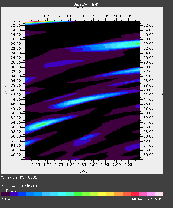
| Estimated Moho Depth: |
10.0 km |
| Estimated Crust Vp/Vs: |
1.60 |
| Assumed Crust Vp: |
6.53 km/s |
| Estimated Crust Vs: |
4.082 km/s |
| Estimated Crust Poisson's Ratio: |
0.18 |
|
| Radial Match: |
93.48886 % |
| Radial Bump: |
347 |
| Transverse Match: |
83.29632 % |
| Transverse Bump: |
400 |
| SOD ConfigId: |
2564 |
| Insert Time: |
2010-03-09 04:36:00.190 +0000 |
| GWidth: |
2.5 |
| Max Bumps: |
400 |
| Tol: |
0.001 |
|

Signal To Noise
| Channel | StoN | STA | LTA |
| GE:SUW: :BHN:20080109T08:34:56.668009Z | 1.7970697 | 7.1697355E-7 | 3.9896815E-7 |
| GE:SUW: :BHE:20080109T08:34:56.668009Z | 14.393769 | 4.405321E-6 | 3.060575E-7 |
| GE:SUW: :BHZ:20080109T08:34:56.668009Z | 20.246655 | 5.136846E-6 | 2.5371332E-7 |
| Arrivals |
| Ps | 1.0 SECOND |
| PpPs | 3.7 SECOND |
| PsPs/PpSs | 4.7 SECOND |


