You are here: Home > Network List > GE - GEOFON Stations List
> Station SUW GEOFON Station Suwalki, Poland > Earthquake Result Viewer
SUW GEOFON Station Suwalki, Poland - Earthquake Result Viewer
| Earthquake location: |
Taiwan Region |
| Earthquake latitude/longitude: |
21.9/121.5 |
| Earthquake time(UTC): |
1996/09/05 (249) 23:42:06 GMT |
| Earthquake Depth: |
20 km |
| Earthquake Magnitude: |
6.4 MB, 6.6 MS, 6.8 UNKNOWN, 6.8 ME |
| Earthquake Catalog/Contributor: |
WHDF/NEIC |
|
| Network: |
GE GEOFON |
| Station: |
SUW GEOFON Station Suwalki, Poland |
| Lat/Lon: |
54.01 N/23.18 E |
| Elevation: |
152 m |
|
| Distance: |
77.3 deg |
| Az: |
323.226 deg |
| Baz: |
70.396 deg |
| Ray Param: |
0.05040547 |
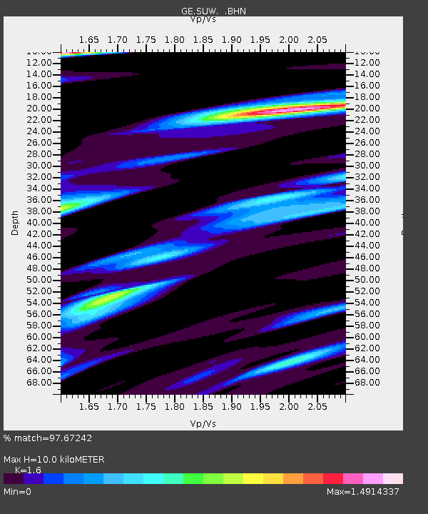
| Estimated Moho Depth: |
10.0 km |
| Estimated Crust Vp/Vs: |
1.60 |
| Assumed Crust Vp: |
6.53 km/s |
| Estimated Crust Vs: |
4.082 km/s |
| Estimated Crust Poisson's Ratio: |
0.18 |
|
| Radial Match: |
97.67242 % |
| Radial Bump: |
392 |
| Transverse Match: |
94.24889 % |
| Transverse Bump: |
400 |
| SOD ConfigId: |
6273 |
| Insert Time: |
2010-03-09 04:36:05.016 +0000 |
| GWidth: |
2.5 |
| Max Bumps: |
400 |
| Tol: |
0.001 |
|

Signal To Noise
| Channel | StoN | STA | LTA |
| GE:SUW: :BHN:19960905T23:53:27.714014Z | 2.9371486 | 1.2795872E-6 | 4.356563E-7 |
| GE:SUW: :BHE:19960905T23:53:27.714014Z | 4.6048107 | 1.8275392E-6 | 3.968761E-7 |
| GE:SUW: :BHZ:19960905T23:53:27.714014Z | 34.6087 | 4.638109E-6 | 1.340157E-7 |
| Arrivals |
| Ps | 1.0 SECOND |
| PpPs | 3.8 SECOND |
| PsPs/PpSs | 4.8 SECOND |


