You are here: Home > Network List > TX - Texas Seismological Network Stations List
> Station DRIO Del Rio > Earthquake Result Viewer
DRIO Del Rio - Earthquake Result Viewer
| Earthquake location: |
South Of Fiji Islands |
| Earthquake latitude/longitude: |
-23.7/-176.9 |
| Earthquake time(UTC): |
2017/09/26 (269) 04:20:00 GMT |
| Earthquake Depth: |
98 km |
| Earthquake Magnitude: |
6.4 mww |
| Earthquake Catalog/Contributor: |
NEIC PDE/us |
|
| Network: |
TX Texas Seismological Network |
| Station: |
DRIO Del Rio |
| Lat/Lon: |
29.42 N/100.62 W |
| Elevation: |
354 m |
|
| Distance: |
90.4 deg |
| Az: |
57.96 deg |
| Baz: |
242.944 deg |
| Ray Param: |
0.041659765 |
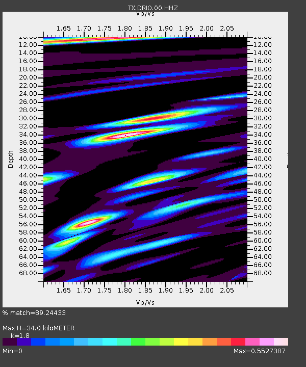
| Estimated Moho Depth: |
34.0 km |
| Estimated Crust Vp/Vs: |
1.80 |
| Assumed Crust Vp: |
6.12 km/s |
| Estimated Crust Vs: |
3.4 km/s |
| Estimated Crust Poisson's Ratio: |
0.28 |
|
| Radial Match: |
89.24433 % |
| Radial Bump: |
260 |
| Transverse Match: |
78.558266 % |
| Transverse Bump: |
354 |
| SOD ConfigId: |
2364251 |
| Insert Time: |
2017-10-10 04:24:52.130 +0000 |
| GWidth: |
2.5 |
| Max Bumps: |
400 |
| Tol: |
0.001 |
|

Signal To Noise
| Channel | StoN | STA | LTA |
| TX:DRIO:00:HHZ:20170926T04:32:19.720022Z | 23.722202 | 1.7188805E-6 | 7.2458725E-8 |
| TX:DRIO:00:HH1:20170926T04:32:19.720022Z | 4.3446827 | 3.4848262E-7 | 8.020899E-8 |
| TX:DRIO:00:HH2:20170926T04:32:19.720022Z | 6.3417726 | 5.098481E-7 | 8.039521E-8 |
| Arrivals |
| Ps | 4.5 SECOND |
| PpPs | 15 SECOND |
| PsPs/PpSs | 20 SECOND |


