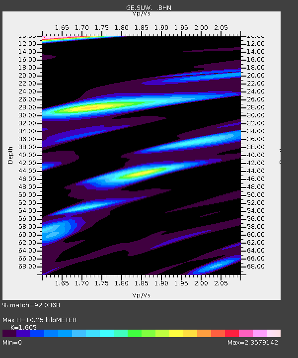
SUW GEOFON Station Suwalki, Poland - Earthquake Result Viewer

Earthquake location: North Of Ascension Island
Earthquake latitude/longitude: -1.3/-14.3
Earthquake time(UTC): 1996/02/18 (049) 23:49:28 GMT
Earthquake Depth: 10 km
Earthquake Magnitude: 6.3 MB, 6.4 MS, 6.6 UNKNOWN, 6.5 MW
Earthquake Catalog/Contributor: WHDF/NEIC
Network: GE GEOFON
Station: SUW GEOFON Station Suwalki, Poland
Lat/Lon: 54.01 N/23.18 E
Elevation: 152 m
Distance: 63.2 deg
Az: 23.704 deg
Baz: 222.921 deg
Ray Param: 0.05971311
Estimated Moho Depth: 10.25 km
Estimated Crust Vp/Vs: 1.61
Assumed Crust Vp: 6.53 km/s
Estimated Crust Vs: 4.069 km/s
Estimated Crust Poisson's Ratio: 0.18
Radial Match: 92.0368 %
Radial Bump: 400
Transverse Match: 77.94567 %
Transverse Bump: 400
SOD ConfigId: 6273
Insert Time: 2010-03-09 04:36:17.448 +0000
GWidth: 2.5
Max Bumps: 400
Tol: 0.001

Signal To Noise

ChannelStoNSTALTA
GE:SUW: :BHN:19960218T23:59:25.278015Z1.14707277.780642E-76.783042E-7
GE:SUW: :BHE:19960218T23:59:25.278015Z0.83284456.2144727E-77.461744E-7
GE:SUW: :BHZ:19960218T23:59:25.278015Z2.67846061.4397333E-65.375227E-7
Arrivals
Ps1.0 SECOND
PpPs3.9 SECOND
PsPs/PpSs4.9 SECOND