You are here: Home > Network List > XW97 - Tien Shan Continental Dynamics Stations List
> Station AKSU XW.AKSU > Earthquake Result Viewer
AKSU XW.AKSU - Earthquake Result Viewer
| Earthquake location: |
Talaud Islands, Indonesia |
| Earthquake latitude/longitude: |
4.1/125.6 |
| Earthquake time(UTC): |
2000/04/03 (094) 15:20:01 GMT |
| Earthquake Depth: |
150 km |
| Earthquake Magnitude: |
5.9 MB, 6.2 MW, 6.0 MW |
| Earthquake Catalog/Contributor: |
WHDF/NEIC |
|
| Network: |
XW Tien Shan Continental Dynamics |
| Station: |
AKSU XW.AKSU |
| Lat/Lon: |
41.14 N/80.11 E |
| Elevation: |
1109 m |
|
| Distance: |
54.9 deg |
| Az: |
318.848 deg |
| Baz: |
119.642 deg |
| Ray Param: |
0.0646246 |
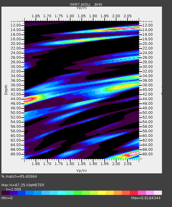
| Estimated Moho Depth: |
67.25 km |
| Estimated Crust Vp/Vs: |
2.09 |
| Assumed Crust Vp: |
6.129 km/s |
| Estimated Crust Vs: |
2.94 km/s |
| Estimated Crust Poisson's Ratio: |
0.35 |
|
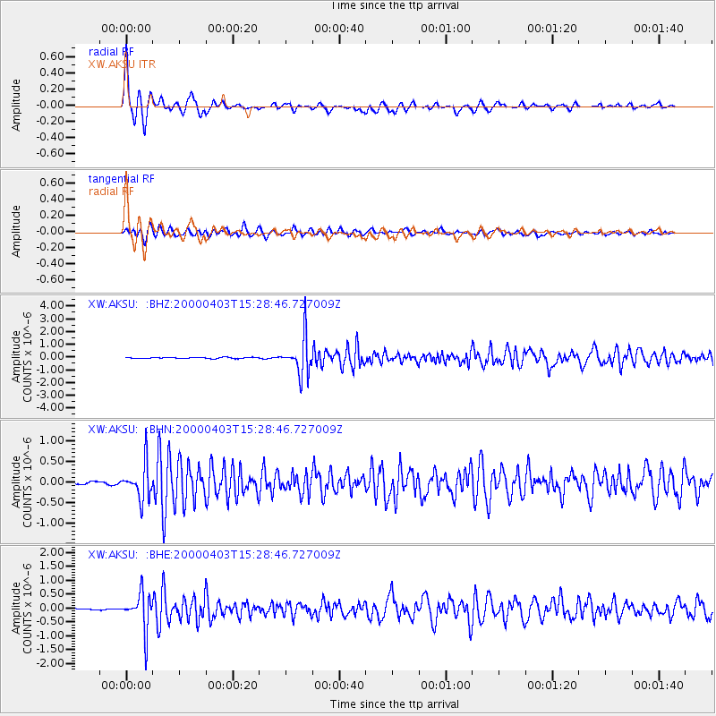
| Radial Match: |
95.60864 % |
| Radial Bump: |
303 |
| Transverse Match: |
84.70034 % |
| Transverse Bump: |
400 |
| SOD ConfigId: |
20082 |
| Insert Time: |
2010-02-26 15:14:33.383 +0000 |
| GWidth: |
2.5 |
| Max Bumps: |
400 |
| Tol: |
0.001 |
|
Signal To Noise
| Channel | StoN | STA | LTA |
| XW:AKSU: :BHN:20000403T15:28:46.727009Z | 9.59545 | 4.2644982E-7 | 4.4442913E-8 |
| XW:AKSU: :BHE:20000403T15:28:46.727009Z | 15.498929 | 6.7012485E-7 | 4.323685E-8 |
| XW:AKSU: :BHZ:20000403T15:28:46.727009Z | 34.42554 | 1.491411E-6 | 4.3322803E-8 |
| Arrivals |
| Ps | 12 SECOND |
| PpPs | 33 SECOND |
| PsPs/PpSs | 45 SECOND |


