You are here: Home > Network List > XW97 - Tien Shan Continental Dynamics Stations List
> Station AKSU XW.AKSU > Earthquake Result Viewer
AKSU XW.AKSU - Earthquake Result Viewer
| Earthquake location: |
Minahassa Peninsula, Sulawesi |
| Earthquake latitude/longitude: |
0.3/122.1 |
| Earthquake time(UTC): |
2000/04/03 (094) 08:55:00 GMT |
| Earthquake Depth: |
187 km |
| Earthquake Magnitude: |
5.6 MB, 5.5 MW, 5.4 MW |
| Earthquake Catalog/Contributor: |
WHDF/NEIC |
|
| Network: |
XW Tien Shan Continental Dynamics |
| Station: |
AKSU XW.AKSU |
| Lat/Lon: |
41.14 N/80.11 E |
| Elevation: |
1109 m |
|
| Distance: |
55.6 deg |
| Az: |
322.289 deg |
| Baz: |
125.913 deg |
| Ray Param: |
0.0640535 |
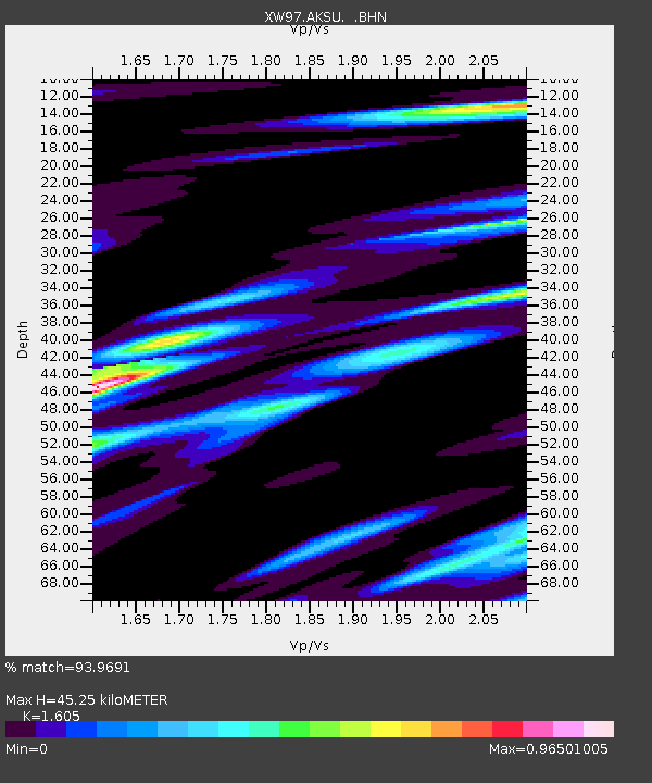
| Estimated Moho Depth: |
45.25 km |
| Estimated Crust Vp/Vs: |
1.61 |
| Assumed Crust Vp: |
6.129 km/s |
| Estimated Crust Vs: |
3.819 km/s |
| Estimated Crust Poisson's Ratio: |
0.18 |
|
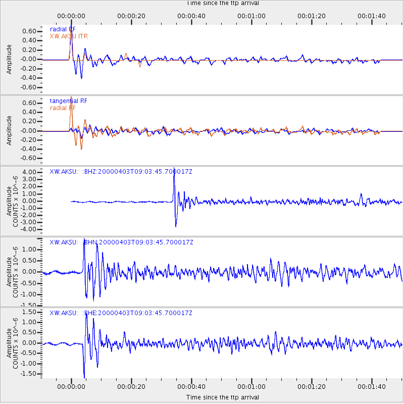
| Radial Match: |
93.9691 % |
| Radial Bump: |
342 |
| Transverse Match: |
80.62099 % |
| Transverse Bump: |
400 |
| SOD ConfigId: |
20082 |
| Insert Time: |
2010-02-26 15:14:34.797 +0000 |
| GWidth: |
2.5 |
| Max Bumps: |
400 |
| Tol: |
0.001 |
|
Signal To Noise
| Channel | StoN | STA | LTA |
| XW:AKSU: :BHN:20000403T09:03:45.700017Z | 8.888719 | 3.954307E-7 | 4.4486804E-8 |
| XW:AKSU: :BHE:20000403T09:03:45.700017Z | 11.675123 | 4.472925E-7 | 3.8311587E-8 |
| XW:AKSU: :BHZ:20000403T09:03:45.700017Z | 29.306765 | 1.2901928E-6 | 4.402372E-8 |
| Arrivals |
| Ps | 4.7 SECOND |
| PpPs | 18 SECOND |
| PsPs/PpSs | 23 SECOND |


