You are here: Home > Network List > GE - GEOFON Stations List
> Station SUW GEOFON Station Suwalki, Poland > Earthquake Result Viewer
SUW GEOFON Station Suwalki, Poland - Earthquake Result Viewer
| Earthquake location: |
Southeast Of Honshu, Japan |
| Earthquake latitude/longitude: |
32.8/140.4 |
| Earthquake time(UTC): |
2009/08/12 (224) 22:48:51 GMT |
| Earthquake Depth: |
53 km |
| Earthquake Magnitude: |
6.2 MB, 6.6 MW, 6.6 MW |
| Earthquake Catalog/Contributor: |
WHDF/NEIC |
|
| Network: |
GE GEOFON |
| Station: |
SUW GEOFON Station Suwalki, Poland |
| Lat/Lon: |
54.01 N/23.18 E |
| Elevation: |
152 m |
|
| Distance: |
78.0 deg |
| Az: |
327.546 deg |
| Baz: |
49.959 deg |
| Ray Param: |
0.04985236 |
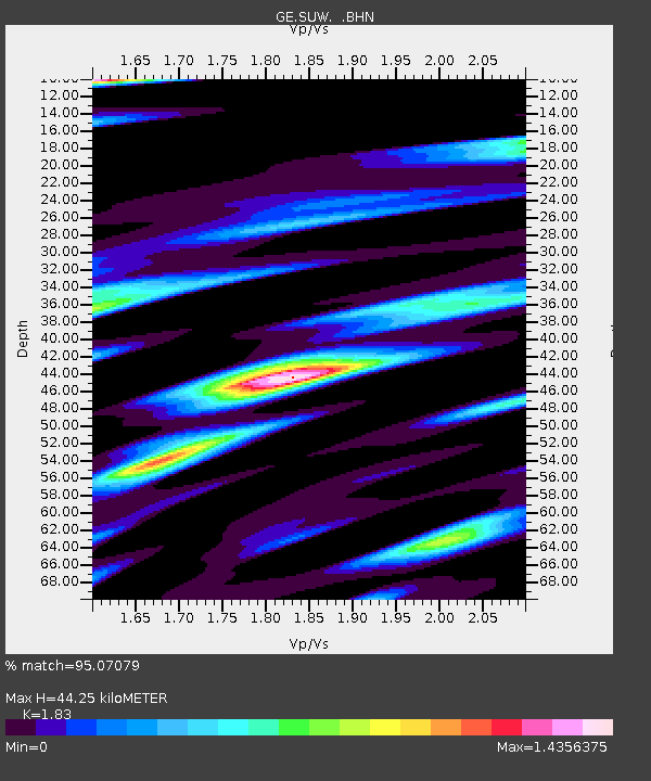
| Estimated Moho Depth: |
44.25 km |
| Estimated Crust Vp/Vs: |
1.83 |
| Assumed Crust Vp: |
6.53 km/s |
| Estimated Crust Vs: |
3.569 km/s |
| Estimated Crust Poisson's Ratio: |
0.29 |
|
| Radial Match: |
95.07079 % |
| Radial Bump: |
395 |
| Transverse Match: |
87.021996 % |
| Transverse Bump: |
400 |
| SOD ConfigId: |
2622 |
| Insert Time: |
2010-03-09 04:37:51.805 +0000 |
| GWidth: |
2.5 |
| Max Bumps: |
400 |
| Tol: |
0.001 |
|

Signal To Noise
| Channel | StoN | STA | LTA |
| GE:SUW: :BHN:20090812T23:00:13.083025Z | 26.069868 | 2.9538762E-6 | 1.1330614E-7 |
| GE:SUW: :BHE:20090812T23:00:13.083025Z | 6.0372424 | 1.6093355E-6 | 2.6656798E-7 |
| GE:SUW: :BHZ:20090812T23:00:13.083025Z | 8.62273 | 1.2692265E-6 | 1.4719542E-7 |
| Arrivals |
| Ps | 5.8 SECOND |
| PpPs | 19 SECOND |
| PsPs/PpSs | 24 SECOND |


