You are here: Home > Network List > GE - GEOFON Stations List
> Station SUW GEOFON Station Suwalki, Poland > Earthquake Result Viewer
SUW GEOFON Station Suwalki, Poland - Earthquake Result Viewer
| Earthquake location: |
Luzon, Philippines |
| Earthquake latitude/longitude: |
14.7/120.0 |
| Earthquake time(UTC): |
1998/08/23 (235) 05:36:12 GMT |
| Earthquake Depth: |
70 km |
| Earthquake Magnitude: |
6.1 MB, 6.1 UNKNOWN, 6.0 MW |
| Earthquake Catalog/Contributor: |
WHDF/NEIC |
|
| Network: |
GE GEOFON |
| Station: |
SUW GEOFON Station Suwalki, Poland |
| Lat/Lon: |
54.01 N/23.18 E |
| Elevation: |
152 m |
|
| Distance: |
82.2 deg |
| Az: |
323.744 deg |
| Baz: |
75.852 deg |
| Ray Param: |
0.046895448 |
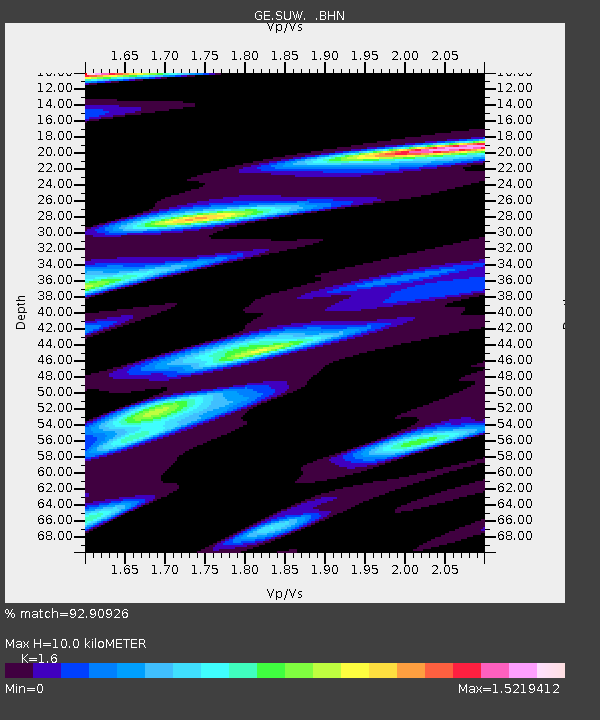
| Estimated Moho Depth: |
10.0 km |
| Estimated Crust Vp/Vs: |
1.60 |
| Assumed Crust Vp: |
6.53 km/s |
| Estimated Crust Vs: |
4.082 km/s |
| Estimated Crust Poisson's Ratio: |
0.18 |
|
| Radial Match: |
92.90926 % |
| Radial Bump: |
400 |
| Transverse Match: |
85.77691 % |
| Transverse Bump: |
400 |
| SOD ConfigId: |
4480 |
| Insert Time: |
2010-03-09 04:38:15.656 +0000 |
| GWidth: |
2.5 |
| Max Bumps: |
400 |
| Tol: |
0.001 |
|

Signal To Noise
| Channel | StoN | STA | LTA |
| GE:SUW: :BHN:19980823T05:47:55.402014Z | 54.619778 | 5.7592088E-6 | 1.0544182E-7 |
| GE:SUW: :BHE:19980823T05:47:55.402014Z | 5.216248 | 1.5115097E-6 | 2.8976953E-7 |
| GE:SUW: :BHZ:19980823T05:47:55.402014Z | 11.304656 | 2.4126964E-6 | 2.1342503E-7 |
| Arrivals |
| Ps | 0.9 SECOND |
| PpPs | 3.9 SECOND |
| PsPs/PpSs | 4.8 SECOND |


