You are here: Home > Network List > US - United States National Seismic Network Stations List
> Station MIAR Mount Ida, Arkansas, USA > Earthquake Result Viewer
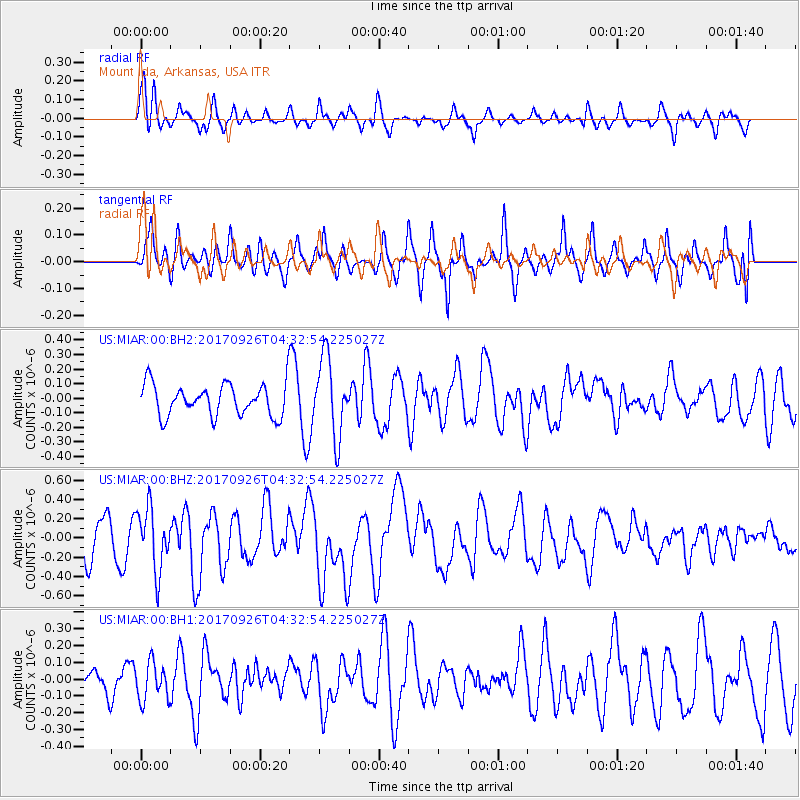
MIAR Mount Ida, Arkansas, USA - Earthquake Result Viewer
*The percent match for this event was below the threshold and hence no stack was calculated.
| Earthquake location: |
South Of Fiji Islands |
| Earthquake latitude/longitude: |
-23.7/-176.9 |
| Earthquake time(UTC): |
2017/09/26 (269) 04:20:00 GMT |
| Earthquake Depth: |
98 km |
| Earthquake Magnitude: |
6.4 mww |
| Earthquake Catalog/Contributor: |
NEIC PDE/us |
|
| Network: |
US United States National Seismic Network |
| Station: |
MIAR Mount Ida, Arkansas, USA |
| Lat/Lon: |
34.55 N/93.58 W |
| Elevation: |
207 m |
|
| Distance: |
97.9 deg |
| Az: |
55.88 deg |
| Baz: |
246.815 deg |
| Ray Param: |
$rayparam |
*The percent match for this event was below the threshold and hence was not used in the summary stack. |
|
| Radial Match: |
66.22848 % |
| Radial Bump: |
354 |
| Transverse Match: |
65.60537 % |
| Transverse Bump: |
381 |
| SOD ConfigId: |
2364251 |
| Insert Time: |
2017-10-10 04:26:30.373 +0000 |
| GWidth: |
2.5 |
| Max Bumps: |
400 |
| Tol: |
0.001 |
|
Signal To Noise
| Channel | StoN | STA | LTA |
| US:MIAR:00:BHZ:20170926T04:32:54.225027Z | 1.7399597 | 3.1876942E-7 | 1.8320506E-7 |
| US:MIAR:00:BH1:20170926T04:32:54.225027Z | 1.1648189 | 1.1083811E-7 | 9.51548E-8 |
| US:MIAR:00:BH2:20170926T04:32:54.225027Z | 2.441391 | 2.672428E-7 | 1.0946333E-7 |
| Arrivals |
| Ps | |
| PpPs | |
| PsPs/PpSs | |


