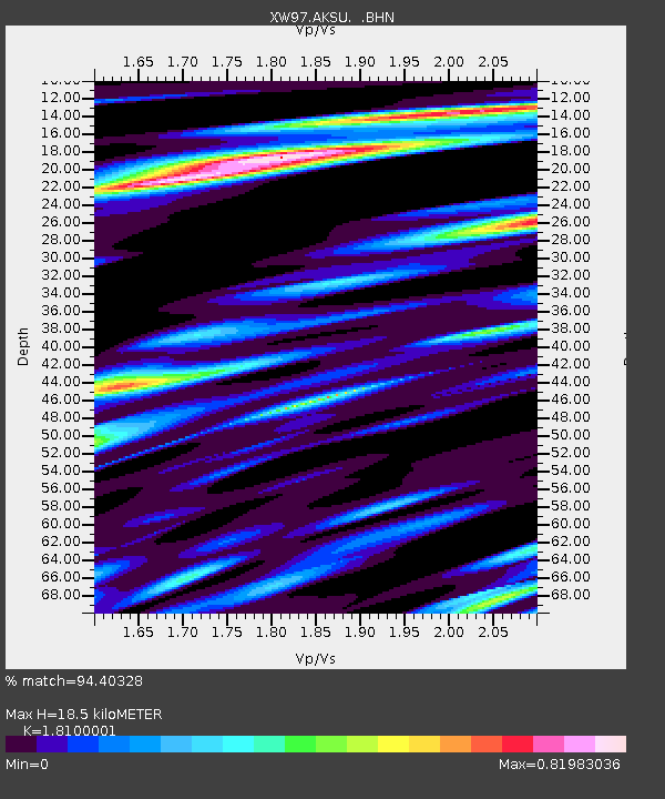
AKSU XW.AKSU - Earthquake Result Viewer
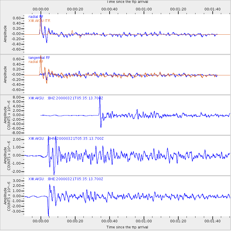
Earthquake location: North Of Halmahera, Indonesia
Earthquake latitude/longitude: 3.2/128.0
Earthquake time(UTC): 2000/03/21 (081) 05:26:07 GMT
Earthquake Depth: 103 km
Earthquake Magnitude: 6.1 MB, 5.3 MS, 6.0 MW, 5.9 MW
Earthquake Catalog/Contributor: WHDF/NEIC
Network: XW Tien Shan Continental Dynamics
Station: AKSU XW.AKSU
Lat/Lon: 41.14 N/80.11 E
Elevation: 1109 m
Distance: 57.2 deg
Az: 318.192 deg
Baz: 118.193 deg
Ray Param: 0.063321695
Estimated Moho Depth: 18.5 km
Estimated Crust Vp/Vs: 1.81
Assumed Crust Vp: 6.129 km/s
Estimated Crust Vs: 3.386 km/s
Estimated Crust Poisson's Ratio: 0.28
Radial Match: 94.40328 %
Radial Bump: 337
Transverse Match: 87.43616 %
Transverse Bump: 400
SOD ConfigId: 20082
Insert Time: 2010-02-26 15:14:37.976 +0000
GWidth: 2.5
Max Bumps: 400
Tol: 0.001

Signal To Noise

ChannelStoNSTALTA
XW:AKSU: :BHN:20000321T05:35:13.700Z7.1008236.46794E-79.108719E-8
XW:AKSU: :BHE:20000321T05:35:13.700Z12.7221461.0243184E-68.0514596E-8
XW:AKSU: :BHZ:20000321T05:35:13.700Z21.9154682.2224617E-61.01410635E-7
Arrivals
Ps2.6 SECOND
PpPs8.1 SECOND
PsPs/PpSs11 SECOND