You are here: Home > Network List > TA - USArray Transportable Network (new EarthScope stations) Stations List
> Station P33M Teslin, Yukon, CA > Earthquake Result Viewer
P33M Teslin, Yukon, CA - Earthquake Result Viewer
| Earthquake location: |
Solomon Islands |
| Earthquake latitude/longitude: |
-10.8/162.5 |
| Earthquake time(UTC): |
2021/01/09 (009) 23:01:12 GMT |
| Earthquake Depth: |
11 km |
| Earthquake Magnitude: |
5.3 Mww |
| Earthquake Catalog/Contributor: |
NEIC PDE/us |
|
| Network: |
TA USArray Transportable Network (new EarthScope stations) |
| Station: |
P33M Teslin, Yukon, CA |
| Lat/Lon: |
60.21 N/132.82 W |
| Elevation: |
1066 m |
|
| Distance: |
87.3 deg |
| Az: |
26.862 deg |
| Baz: |
242.746 deg |
| Ray Param: |
0.043451983 |
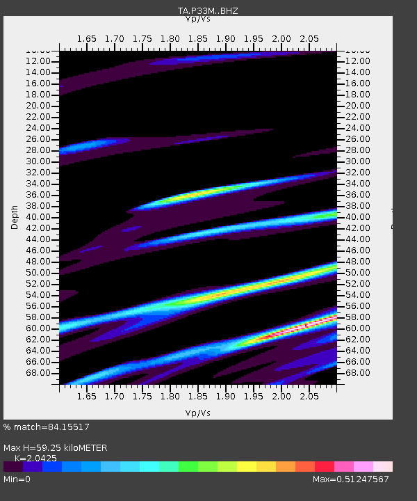
| Estimated Moho Depth: |
59.25 km |
| Estimated Crust Vp/Vs: |
2.04 |
| Assumed Crust Vp: |
6.419 km/s |
| Estimated Crust Vs: |
3.143 km/s |
| Estimated Crust Poisson's Ratio: |
0.34 |
|
| Radial Match: |
84.15517 % |
| Radial Bump: |
379 |
| Transverse Match: |
69.782425 % |
| Transverse Bump: |
400 |
| SOD ConfigId: |
23341671 |
| Insert Time: |
2021-01-24 00:12:06.669 +0000 |
| GWidth: |
2.5 |
| Max Bumps: |
400 |
| Tol: |
0.001 |
|

Signal To Noise
| Channel | StoN | STA | LTA |
| TA:P33M: :BHZ:20210109T23:13:27.575011Z | 1.407043 | 1.1687733E-6 | 8.3065925E-7 |
| TA:P33M: :BHN:20210109T23:13:27.575011Z | 2.013716 | 1.4723734E-6 | 7.311723E-7 |
| TA:P33M: :BHE:20210109T23:13:27.575011Z | 1.0045075 | 6.730123E-7 | 6.6999235E-7 |
| Arrivals |
| Ps | 9.8 SECOND |
| PpPs | 28 SECOND |
| PsPs/PpSs | 37 SECOND |


