You are here: Home > Network List > US - United States National Seismic Network Stations List
> Station WMOK Wichita Mountains, Oklahoma, USA > Earthquake Result Viewer
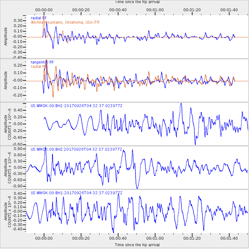
WMOK Wichita Mountains, Oklahoma, USA - Earthquake Result Viewer
*The percent match for this event was below the threshold and hence no stack was calculated.
| Earthquake location: |
South Of Fiji Islands |
| Earthquake latitude/longitude: |
-23.7/-176.9 |
| Earthquake time(UTC): |
2017/09/26 (269) 04:20:00 GMT |
| Earthquake Depth: |
98 km |
| Earthquake Magnitude: |
6.4 mww |
| Earthquake Catalog/Contributor: |
NEIC PDE/us |
|
| Network: |
US United States National Seismic Network |
| Station: |
WMOK Wichita Mountains, Oklahoma, USA |
| Lat/Lon: |
34.74 N/98.78 W |
| Elevation: |
486 m |
|
| Distance: |
94.1 deg |
| Az: |
53.912 deg |
| Baz: |
244.075 deg |
| Ray Param: |
$rayparam |
*The percent match for this event was below the threshold and hence was not used in the summary stack. |
|
| Radial Match: |
58.332554 % |
| Radial Bump: |
400 |
| Transverse Match: |
53.54674 % |
| Transverse Bump: |
400 |
| SOD ConfigId: |
2364251 |
| Insert Time: |
2017-10-10 04:26:55.084 +0000 |
| GWidth: |
2.5 |
| Max Bumps: |
400 |
| Tol: |
0.001 |
|
Signal To Noise
| Channel | StoN | STA | LTA |
| US:WMOK:00:BHZ:20170926T04:32:37.023977Z | 3.8077815 | 4.981894E-7 | 1.3083456E-7 |
| US:WMOK:00:BH1:20170926T04:32:37.023977Z | 1.2241601 | 1.3568739E-7 | 1.1084122E-7 |
| US:WMOK:00:BH2:20170926T04:32:37.023977Z | 1.4681963 | 1.9399306E-7 | 1.321302E-7 |
| Arrivals |
| Ps | |
| PpPs | |
| PsPs/PpSs | |


