You are here: Home > Network List > GE - GEOFON Stations List
> Station SUW GEOFON Station Suwalki, Poland > Earthquake Result Viewer
SUW GEOFON Station Suwalki, Poland - Earthquake Result Viewer
| Earthquake location: |
Southern Iran |
| Earthquake latitude/longitude: |
28.3/57.2 |
| Earthquake time(UTC): |
1999/03/04 (063) 05:38:26 GMT |
| Earthquake Depth: |
33 km |
| Earthquake Magnitude: |
6.2 MB, 6.5 MS, 6.6 MW, 6.4 MW |
| Earthquake Catalog/Contributor: |
WHDF/NEIC |
|
| Network: |
GE GEOFON |
| Station: |
SUW GEOFON Station Suwalki, Poland |
| Lat/Lon: |
54.01 N/23.18 E |
| Elevation: |
152 m |
|
| Distance: |
35.7 deg |
| Az: |
325.509 deg |
| Baz: |
122.249 deg |
| Ray Param: |
0.07704197 |
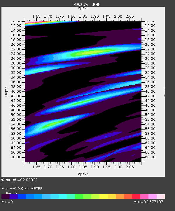
| Estimated Moho Depth: |
10.0 km |
| Estimated Crust Vp/Vs: |
1.60 |
| Assumed Crust Vp: |
6.53 km/s |
| Estimated Crust Vs: |
4.082 km/s |
| Estimated Crust Poisson's Ratio: |
0.18 |
|
| Radial Match: |
92.02322 % |
| Radial Bump: |
378 |
| Transverse Match: |
73.159775 % |
| Transverse Bump: |
400 |
| SOD ConfigId: |
4480 |
| Insert Time: |
2010-03-09 04:39:07.057 +0000 |
| GWidth: |
2.5 |
| Max Bumps: |
400 |
| Tol: |
0.001 |
|

Signal To Noise
| Channel | StoN | STA | LTA |
| GE:SUW: :BHN:19990304T05:44:51.141002Z | 9.688568 | 3.2376165E-6 | 3.3416873E-7 |
| GE:SUW: :BHE:19990304T05:44:51.141002Z | 1.3092933 | 8.6449535E-7 | 6.602763E-7 |
| GE:SUW: :BHZ:19990304T05:44:51.141002Z | 3.4611104 | 1.4430592E-6 | 4.169353E-7 |
| Arrivals |
| Ps | 1.0 SECOND |
| PpPs | 3.6 SECOND |
| PsPs/PpSs | 4.7 SECOND |


