You are here: Home > Network List > CI - Caltech Regional Seismic Network Stations List
> Station MPM Manuel Prospect Mine, California, USA > Earthquake Result Viewer
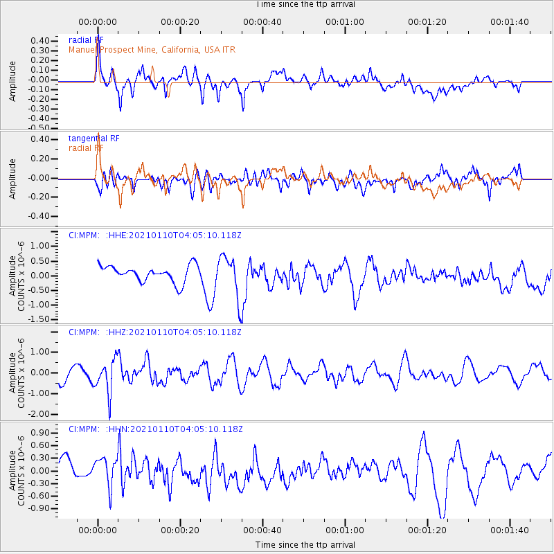
MPM Manuel Prospect Mine, California, USA - Earthquake Result Viewer
*The percent match for this event was below the threshold and hence no stack was calculated.
| Earthquake location: |
Salta Province, Argentina |
| Earthquake latitude/longitude: |
-24.0/-66.7 |
| Earthquake time(UTC): |
2021/01/10 (010) 03:54:12 GMT |
| Earthquake Depth: |
203 km |
| Earthquake Magnitude: |
6.1 mww |
| Earthquake Catalog/Contributor: |
NEIC PDE/us |
|
| Network: |
CI Caltech Regional Seismic Network |
| Station: |
MPM Manuel Prospect Mine, California, USA |
| Lat/Lon: |
36.06 N/117.49 W |
| Elevation: |
185 m |
|
| Distance: |
76.6 deg |
| Az: |
319.794 deg |
| Baz: |
133.241 deg |
| Ray Param: |
$rayparam |
*The percent match for this event was below the threshold and hence was not used in the summary stack. |
|
| Radial Match: |
48.137344 % |
| Radial Bump: |
400 |
| Transverse Match: |
68.91227 % |
| Transverse Bump: |
400 |
| SOD ConfigId: |
23341671 |
| Insert Time: |
2021-01-24 04:59:35.460 +0000 |
| GWidth: |
2.5 |
| Max Bumps: |
400 |
| Tol: |
0.001 |
|
Signal To Noise
| Channel | StoN | STA | LTA |
| CI:MPM: :HHZ:20210110T04:05:10.118Z | 2.6251388 | 8.159849E-7 | 3.1083496E-7 |
| CI:MPM: :HHN:20210110T04:05:10.118Z | 1.6883535 | 3.39809E-7 | 2.0126649E-7 |
| CI:MPM: :HHE:20210110T04:05:10.118Z | 2.674372 | 7.2992464E-7 | 2.7293308E-7 |
| Arrivals |
| Ps | |
| PpPs | |
| PsPs/PpSs | |


