You are here: Home > Network List > GE - GEOFON Stations List
> Station SUW GEOFON Station Suwalki, Poland > Earthquake Result Viewer
SUW GEOFON Station Suwalki, Poland - Earthquake Result Viewer
| Earthquake location: |
Lake Tanganyika Region |
| Earthquake latitude/longitude: |
-8.0/30.7 |
| Earthquake time(UTC): |
2000/10/02 (276) 02:25:31 GMT |
| Earthquake Depth: |
34 km |
| Earthquake Magnitude: |
6.1 MB, 6.7 MS, 6.5 MW, 6.2 ME |
| Earthquake Catalog/Contributor: |
WHDF/NEIC |
|
| Network: |
GE GEOFON |
| Station: |
SUW GEOFON Station Suwalki, Poland |
| Lat/Lon: |
54.01 N/23.18 E |
| Elevation: |
152 m |
|
| Distance: |
62.1 deg |
| Az: |
354.98 deg |
| Baz: |
171.555 deg |
| Ray Param: |
0.060404424 |
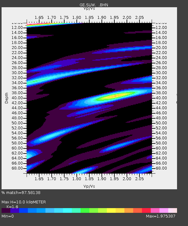
| Estimated Moho Depth: |
10.0 km |
| Estimated Crust Vp/Vs: |
1.60 |
| Assumed Crust Vp: |
6.53 km/s |
| Estimated Crust Vs: |
4.082 km/s |
| Estimated Crust Poisson's Ratio: |
0.18 |
|
| Radial Match: |
97.58138 % |
| Radial Bump: |
400 |
| Transverse Match: |
90.760956 % |
| Transverse Bump: |
400 |
| SOD ConfigId: |
3744 |
| Insert Time: |
2010-03-09 04:39:13.382 +0000 |
| GWidth: |
2.5 |
| Max Bumps: |
400 |
| Tol: |
0.001 |
|

Signal To Noise
| Channel | StoN | STA | LTA |
| GE:SUW: :BHN:20001002T02:35:17.887026Z | 8.57998 | 2.3863317E-6 | 2.781279E-7 |
| GE:SUW: :BHE:20001002T02:35:17.887026Z | 2.194184 | 4.9857863E-7 | 2.2722735E-7 |
| GE:SUW: :BHZ:20001002T02:35:17.887026Z | 30.25737 | 4.0930354E-6 | 1.3527401E-7 |
| Arrivals |
| Ps | 1.0 SECOND |
| PpPs | 3.8 SECOND |
| PsPs/PpSs | 4.7 SECOND |


