You are here: Home > Network List > GE - GEOFON Stations List
> Station SUW GEOFON Station Suwalki, Poland > Earthquake Result Viewer
SUW GEOFON Station Suwalki, Poland - Earthquake Result Viewer
| Earthquake location: |
Taiwan |
| Earthquake latitude/longitude: |
23.8/121.2 |
| Earthquake time(UTC): |
2000/06/10 (162) 18:23:29 GMT |
| Earthquake Depth: |
33 km |
| Earthquake Magnitude: |
6.2 MB, 6.2 MS, 6.4 MW, 6.3 MW |
| Earthquake Catalog/Contributor: |
WHDF/NEIC |
|
| Network: |
GE GEOFON |
| Station: |
SUW GEOFON Station Suwalki, Poland |
| Lat/Lon: |
54.01 N/23.18 E |
| Elevation: |
152 m |
|
| Distance: |
75.6 deg |
| Az: |
322.888 deg |
| Baz: |
69.406 deg |
| Ray Param: |
0.051519275 |
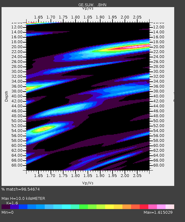
| Estimated Moho Depth: |
10.0 km |
| Estimated Crust Vp/Vs: |
1.60 |
| Assumed Crust Vp: |
6.53 km/s |
| Estimated Crust Vs: |
4.082 km/s |
| Estimated Crust Poisson's Ratio: |
0.18 |
|
| Radial Match: |
96.54674 % |
| Radial Bump: |
372 |
| Transverse Match: |
91.44587 % |
| Transverse Bump: |
394 |
| SOD ConfigId: |
3744 |
| Insert Time: |
2010-03-09 04:39:21.134 +0000 |
| GWidth: |
2.5 |
| Max Bumps: |
400 |
| Tol: |
0.001 |
|

Signal To Noise
| Channel | StoN | STA | LTA |
| GE:SUW: :BHN:20000610T18:34:39.786003Z | 6.1070557 | 9.864364E-7 | 1.6152406E-7 |
| GE:SUW: :BHE:20000610T18:34:39.786003Z | 8.836434 | 1.433835E-6 | 1.6226397E-7 |
| GE:SUW: :BHZ:20000610T18:34:39.786003Z | 47.80358 | 4.0282807E-6 | 8.426734E-8 |
| Arrivals |
| Ps | 1.0 SECOND |
| PpPs | 3.8 SECOND |
| PsPs/PpSs | 4.8 SECOND |


