You are here: Home > Network List > XW97 - Tien Shan Continental Dynamics Stations List
> Station AKSU XW.AKSU > Earthquake Result Viewer
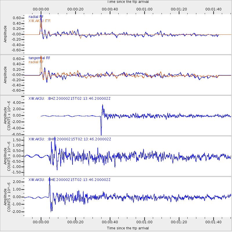
AKSU XW.AKSU - Earthquake Result Viewer

| Earthquake location: |
Mariana Islands |
| Earthquake latitude/longitude: |
17.7/145.4 |
| Earthquake time(UTC): |
2000/02/15 (046) 02:05:00 GMT |
| Earthquake Depth: |
522 km |
| Earthquake Magnitude: |
5.9 MB, 5.9 MW, 5.8 MW |
| Earthquake Catalog/Contributor: |
WHDF/NEIC |
|
| Network: |
XW Tien Shan Continental Dynamics |
| Station: |
AKSU XW.AKSU |
| Lat/Lon: |
41.14 N/80.11 E |
| Elevation: |
1109 m |
|
| Distance: |
60.1 deg |
| Az: |
307.666 deg |
| Baz: |
92.202 deg |
| Ray Param: |
0.059757248 |
| Estimated Moho Depth: |
45.25 km |
| Estimated Crust Vp/Vs: |
2.00 |
| Assumed Crust Vp: |
6.129 km/s |
| Estimated Crust Vs: |
3.072 km/s |
| Estimated Crust Poisson's Ratio: |
0.33 |
|
| Radial Match: |
81.91139 % |
| Radial Bump: |
400 |
| Transverse Match: |
58.944336 % |
| Transverse Bump: |
400 |
| SOD ConfigId: |
20082 |
| Insert Time: |
2010-02-26 15:14:41.845 +0000 |
| GWidth: |
2.5 |
| Max Bumps: |
400 |
| Tol: |
0.001 |
|
Signal To Noise
| Channel | StoN | STA | LTA |
| XW:AKSU: :BHN:20000215T02:13:46.200002Z | 1.0286405 | 1.1402128E-7 | 1.1084658E-7 |
| XW:AKSU: :BHE:20000215T02:13:46.200002Z | 4.1095867 | 2.5863332E-7 | 6.293414E-8 |
| XW:AKSU: :BHZ:20000215T02:13:46.200002Z | 7.825095 | 7.087265E-7 | 9.057097E-8 |
| Arrivals |
| Ps | 7.6 SECOND |
| PpPs | 21 SECOND |
| PsPs/PpSs | 29 SECOND |


