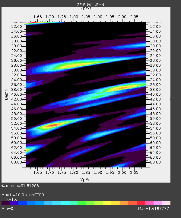
SUW GEOFON Station Suwalki, Poland - Earthquake Result Viewer

Earthquake location: Near East Coast Of Kamchatka
Earthquake latitude/longitude: 56.3/163.8
Earthquake time(UTC): 2001/08/02 (214) 23:41:06 GMT
Earthquake Depth: 14 km
Earthquake Magnitude: 5.9 MB, 6.2 MS, 6.3 MW, 6.2 ME
Earthquake Catalog/Contributor: WHDF/NEIC
Network: GE GEOFON
Station: SUW GEOFON Station Suwalki, Poland
Lat/Lon: 54.01 N/23.18 E
Elevation: 152 m
Distance: 65.5 deg
Az: 335.686 deg
Baz: 22.91 deg
Ray Param: 0.058250964
Estimated Moho Depth: 10.0 km
Estimated Crust Vp/Vs: 1.60
Assumed Crust Vp: 6.53 km/s
Estimated Crust Vs: 4.082 km/s
Estimated Crust Poisson's Ratio: 0.18
Radial Match: 91.51285 %
Radial Bump: 394
Transverse Match: 69.37123 %
Transverse Bump: 400
SOD ConfigId: 3753
Insert Time: 2010-03-09 04:40:39.314 +0000
GWidth: 2.5
Max Bumps: 400
Tol: 0.001

Signal To Noise

ChannelStoNSTALTA
GE:SUW: :BHN:20010802T23:51:17.386003Z2.75452839.2380117E-73.3537546E-7
GE:SUW: :BHE:20010802T23:51:17.386003Z0.986355363.2509988E-73.295971E-7
GE:SUW: :BHZ:20010802T23:51:17.386003Z10.4987971.6989194E-61.6182038E-7
Arrivals
Ps1.0 SECOND
PpPs3.8 SECOND
PsPs/PpSs4.8 SECOND