You are here: Home > Network List > GE - GEOFON Stations List
> Station SUW GEOFON Station Suwalki, Poland > Earthquake Result Viewer
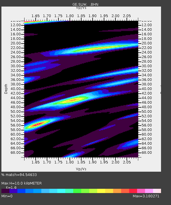
SUW GEOFON Station Suwalki, Poland - Earthquake Result Viewer
| Earthquake location: |
Hindu Kush Region, Afghanistan |
| Earthquake latitude/longitude: |
36.5/70.5 |
| Earthquake time(UTC): |
2002/03/03 (062) 12:08:19 GMT |
| Earthquake Depth: |
226 km |
| Earthquake Magnitude: |
6.6 MB, 7.4 MW, 7.3 MW |
| Earthquake Catalog/Contributor: |
WHDF/NEIC |
|
| Network: |
GE GEOFON |
| Station: |
SUW GEOFON Station Suwalki, Poland |
| Lat/Lon: |
54.01 N/23.18 E |
| Elevation: |
152 m |
|
| Distance: |
36.8 deg |
| Az: |
313.624 deg |
| Baz: |
98.788 deg |
| Ray Param: |
0.075615115 |
| Estimated Moho Depth: |
10.0 km |
| Estimated Crust Vp/Vs: |
1.60 |
| Assumed Crust Vp: |
6.53 km/s |
| Estimated Crust Vs: |
4.082 km/s |
| Estimated Crust Poisson's Ratio: |
0.18 |
|
| Radial Match: |
94.54633 % |
| Radial Bump: |
265 |
| Transverse Match: |
74.10401 % |
| Transverse Bump: |
400 |
| SOD ConfigId: |
20082 |
| Insert Time: |
2010-03-09 04:40:58.647 +0000 |
| GWidth: |
2.5 |
| Max Bumps: |
400 |
| Tol: |
0.001 |
|

Signal To Noise
| Channel | StoN | STA | LTA |
| GE:SUW: :BHN:20020303T12:14:35.535013Z | 3.5914593 | 2.7170925E-6 | 7.5654276E-7 |
| GE:SUW: :BHE:20020303T12:14:35.535013Z | 19.577703 | 2.8310256E-5 | 1.4460459E-6 |
| GE:SUW: :BHZ:20020303T12:14:35.535013Z | 15.995335 | 2.937273E-5 | 1.8363311E-6 |
| Arrivals |
| Ps | 1.0 SECOND |
| PpPs | 3.7 SECOND |
| PsPs/PpSs | 4.7 SECOND |


