You are here: Home > Network List > GE - GEOFON Stations List
> Station SUW GEOFON Station Suwalki, Poland > Earthquake Result Viewer
SUW GEOFON Station Suwalki, Poland - Earthquake Result Viewer
| Earthquake location: |
Hindu Kush Region, Afghanistan |
| Earthquake latitude/longitude: |
36.1/70.7 |
| Earthquake time(UTC): |
2002/01/03 (003) 07:05:27 GMT |
| Earthquake Depth: |
129 km |
| Earthquake Magnitude: |
5.8 MB, 6.2 MW, 6.1 MW |
| Earthquake Catalog/Contributor: |
WHDF/NEIC |
|
| Network: |
GE GEOFON |
| Station: |
SUW GEOFON Station Suwalki, Poland |
| Lat/Lon: |
54.01 N/23.18 E |
| Elevation: |
152 m |
|
| Distance: |
37.2 deg |
| Az: |
313.988 deg |
| Baz: |
99.093 deg |
| Ray Param: |
0.07580655 |
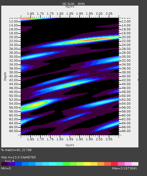
| Estimated Moho Depth: |
10.0 km |
| Estimated Crust Vp/Vs: |
1.60 |
| Assumed Crust Vp: |
6.53 km/s |
| Estimated Crust Vs: |
4.082 km/s |
| Estimated Crust Poisson's Ratio: |
0.18 |
|
| Radial Match: |
91.21769 % |
| Radial Bump: |
392 |
| Transverse Match: |
69.65797 % |
| Transverse Bump: |
400 |
| SOD ConfigId: |
20082 |
| Insert Time: |
2010-03-09 04:41:01.579 +0000 |
| GWidth: |
2.5 |
| Max Bumps: |
400 |
| Tol: |
0.001 |
|

Signal To Noise
| Channel | StoN | STA | LTA |
| GE:SUW: :BHN:20020103T07:11:56.185015Z | 1.4197481 | 9.608403E-7 | 6.767682E-7 |
| GE:SUW: :BHE:20020103T07:11:56.185015Z | 6.406498 | 3.197791E-6 | 4.991481E-7 |
| GE:SUW: :BHZ:20020103T07:11:56.185015Z | 7.4600387 | 3.2676141E-6 | 4.380157E-7 |
| Arrivals |
| Ps | 1.0 SECOND |
| PpPs | 3.7 SECOND |
| PsPs/PpSs | 4.7 SECOND |


