You are here: Home > Network List > GE - GEOFON Stations List
> Station SUW GEOFON Station Suwalki, Poland > Earthquake Result Viewer
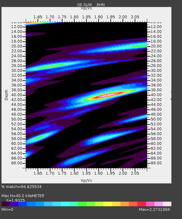
SUW GEOFON Station Suwalki, Poland - Earthquake Result Viewer
| Earthquake location: |
Central Alaska |
| Earthquake latitude/longitude: |
63.5/-147.4 |
| Earthquake time(UTC): |
2002/11/03 (307) 22:12:41 GMT |
| Earthquake Depth: |
4.9 km |
| Earthquake Magnitude: |
7.0 MB, 8.5 MS, 7.9 MW |
| Earthquake Catalog/Contributor: |
WHDF/NEIC |
|
| Network: |
GE GEOFON |
| Station: |
SUW GEOFON Station Suwalki, Poland |
| Lat/Lon: |
54.01 N/23.18 E |
| Elevation: |
152 m |
|
| Distance: |
62.6 deg |
| Az: |
6.218 deg |
| Baz: |
355.281 deg |
| Ray Param: |
0.060143862 |
| Estimated Moho Depth: |
40.0 km |
| Estimated Crust Vp/Vs: |
1.93 |
| Assumed Crust Vp: |
6.53 km/s |
| Estimated Crust Vs: |
3.379 km/s |
| Estimated Crust Poisson's Ratio: |
0.32 |
|
| Radial Match: |
94.625534 % |
| Radial Bump: |
400 |
| Transverse Match: |
87.80661 % |
| Transverse Bump: |
400 |
| SOD ConfigId: |
4714 |
| Insert Time: |
2010-03-09 04:41:05.086 +0000 |
| GWidth: |
2.5 |
| Max Bumps: |
400 |
| Tol: |
0.001 |
|

Signal To Noise
| Channel | StoN | STA | LTA |
| GE:SUW: :BHN:20021103T22:22:34.843018Z | 5.8748393 | 2.7955607E-6 | 4.7585317E-7 |
| GE:SUW: :BHE:20021103T22:22:34.843018Z | 2.7284422 | 1.0158112E-6 | 3.7230447E-7 |
| GE:SUW: :BHZ:20021103T22:22:34.843018Z | 15.551227 | 8.097816E-6 | 5.207188E-7 |
| Arrivals |
| Ps | 6.0 SECOND |
| PpPs | 17 SECOND |
| PsPs/PpSs | 23 SECOND |


