You are here: Home > Network List > XW97 - Tien Shan Continental Dynamics Stations List
> Station AKSU XW.AKSU > Earthquake Result Viewer
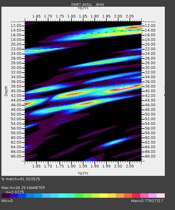
AKSU XW.AKSU - Earthquake Result Viewer
| Earthquake location: |
Northeast Of Taiwan |
| Earthquake latitude/longitude: |
26.1/124.5 |
| Earthquake time(UTC): |
2000/01/28 (028) 16:39:24 GMT |
| Earthquake Depth: |
194 km |
| Earthquake Magnitude: |
6.1 MB, 6.0 MW, 6.0 MW |
| Earthquake Catalog/Contributor: |
WHDF/NEIC |
|
| Network: |
XW Tien Shan Continental Dynamics |
| Station: |
AKSU XW.AKSU |
| Lat/Lon: |
41.14 N/80.11 E |
| Elevation: |
1109 m |
|
| Distance: |
39.5 deg |
| Az: |
303.791 deg |
| Baz: |
98.239 deg |
| Ray Param: |
0.07423899 |
| Estimated Moho Depth: |
38.25 km |
| Estimated Crust Vp/Vs: |
2.02 |
| Assumed Crust Vp: |
6.129 km/s |
| Estimated Crust Vs: |
3.03 km/s |
| Estimated Crust Poisson's Ratio: |
0.34 |
|
| Radial Match: |
91.503525 % |
| Radial Bump: |
312 |
| Transverse Match: |
76.75198 % |
| Transverse Bump: |
400 |
| SOD ConfigId: |
20082 |
| Insert Time: |
2010-02-26 15:14:43.955 +0000 |
| GWidth: |
2.5 |
| Max Bumps: |
400 |
| Tol: |
0.001 |
|

Signal To Noise
| Channel | StoN | STA | LTA |
| XW:AKSU: :BHN:20000128T16:46:05.204011Z | 3.5211413 | 5.0992E-7 | 1.4481668E-7 |
| XW:AKSU: :BHE:20000128T16:46:05.204011Z | 18.372192 | 2.0037387E-6 | 1.0906366E-7 |
| XW:AKSU: :BHZ:20000128T16:46:05.204011Z | 28.664934 | 3.0659853E-6 | 1.0695944E-7 |
| Arrivals |
| Ps | 6.7 SECOND |
| PpPs | 18 SECOND |
| PsPs/PpSs | 25 SECOND |


