You are here: Home > Network List > GE - GEOFON Stations List
> Station SUW GEOFON Station Suwalki, Poland > Earthquake Result Viewer
SUW GEOFON Station Suwalki, Poland - Earthquake Result Viewer
| Earthquake location: |
Mindoro, Philippines |
| Earthquake latitude/longitude: |
13.9/120.5 |
| Earthquake time(UTC): |
2004/10/08 (282) 14:36:06 GMT |
| Earthquake Depth: |
105 km |
| Earthquake Magnitude: |
6.3 MB, 6.5 MW, 6.4 MW |
| Earthquake Catalog/Contributor: |
WHDF/NEIC |
|
| Network: |
GE GEOFON |
| Station: |
SUW GEOFON Station Suwalki, Poland |
| Lat/Lon: |
54.01 N/23.18 E |
| Elevation: |
152 m |
|
| Distance: |
83.1 deg |
| Az: |
323.873 deg |
| Baz: |
75.924 deg |
| Ray Param: |
0.046178967 |
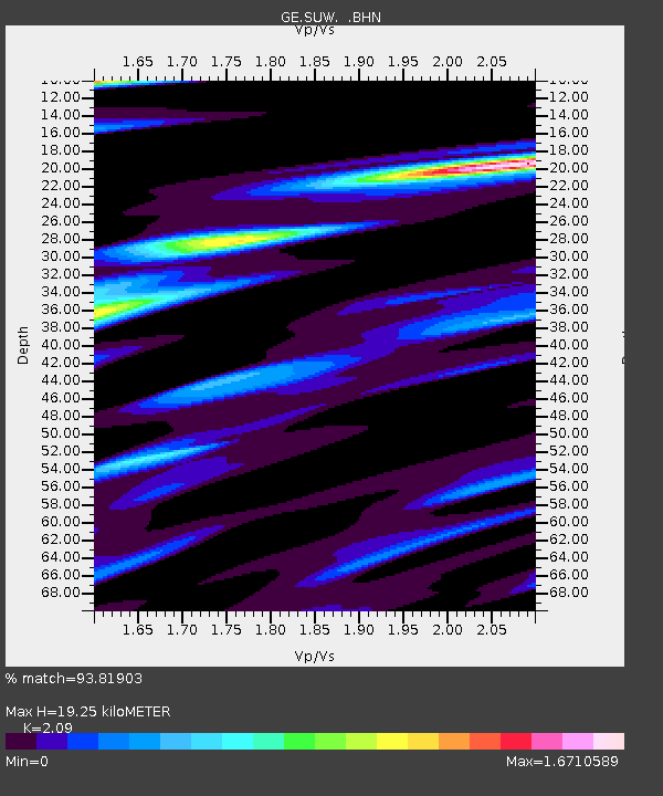
| Estimated Moho Depth: |
19.25 km |
| Estimated Crust Vp/Vs: |
2.09 |
| Assumed Crust Vp: |
6.53 km/s |
| Estimated Crust Vs: |
3.125 km/s |
| Estimated Crust Poisson's Ratio: |
0.35 |
|
| Radial Match: |
93.81903 % |
| Radial Bump: |
323 |
| Transverse Match: |
84.79298 % |
| Transverse Bump: |
365 |
| SOD ConfigId: |
2459 |
| Insert Time: |
2010-03-09 04:41:39.569 +0000 |
| GWidth: |
2.5 |
| Max Bumps: |
400 |
| Tol: |
0.001 |
|

Signal To Noise
| Channel | StoN | STA | LTA |
| GE:SUW: :BHN:20041008T14:47:49.222Z | 2.5378401 | 1.057907E-6 | 4.1685325E-7 |
| GE:SUW: :BHE:20041008T14:47:49.222Z | 5.0803905 | 1.4846141E-6 | 2.922244E-7 |
| GE:SUW: :BHZ:20041008T14:47:49.222Z | 23.345465 | 4.601181E-6 | 1.97091E-7 |
| Arrivals |
| Ps | 3.3 SECOND |
| PpPs | 8.9 SECOND |
| PsPs/PpSs | 12 SECOND |


