You are here: Home > Network List > GE - GEOFON Stations List
> Station SUW GEOFON Station Suwalki, Poland > Earthquake Result Viewer
SUW GEOFON Station Suwalki, Poland - Earthquake Result Viewer
| Earthquake location: |
Xizang |
| Earthquake latitude/longitude: |
30.7/83.7 |
| Earthquake time(UTC): |
2004/07/11 (193) 23:08:44 GMT |
| Earthquake Depth: |
13 km |
| Earthquake Magnitude: |
5.7 MB, 6.2 MS, 6.2 MW, 6.2 MW |
| Earthquake Catalog/Contributor: |
WHDF/NEIC |
|
| Network: |
GE GEOFON |
| Station: |
SUW GEOFON Station Suwalki, Poland |
| Lat/Lon: |
54.01 N/23.18 E |
| Elevation: |
152 m |
|
| Distance: |
48.7 deg |
| Az: |
316.84 deg |
| Baz: |
93.263 deg |
| Ray Param: |
0.069201365 |
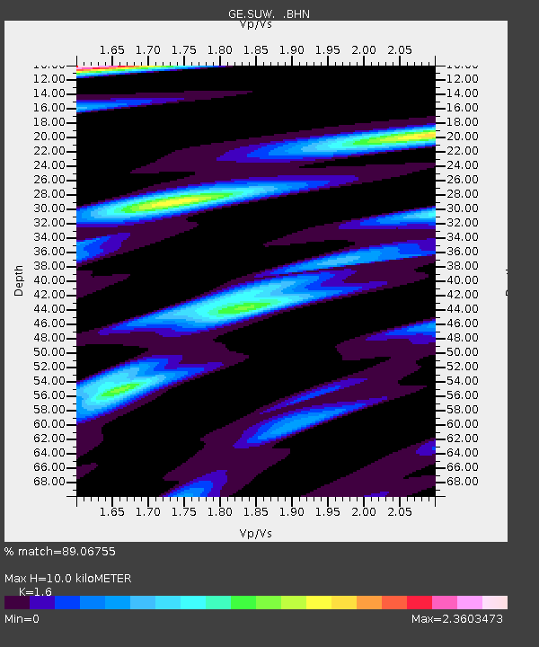
| Estimated Moho Depth: |
10.0 km |
| Estimated Crust Vp/Vs: |
1.60 |
| Assumed Crust Vp: |
6.53 km/s |
| Estimated Crust Vs: |
4.082 km/s |
| Estimated Crust Poisson's Ratio: |
0.18 |
|
| Radial Match: |
89.06755 % |
| Radial Bump: |
400 |
| Transverse Match: |
65.99403 % |
| Transverse Bump: |
400 |
| SOD ConfigId: |
2459 |
| Insert Time: |
2010-03-09 04:41:56.357 +0000 |
| GWidth: |
2.5 |
| Max Bumps: |
400 |
| Tol: |
0.001 |
|

Signal To Noise
| Channel | StoN | STA | LTA |
| GE:SUW: :BHN:20040711T23:16:56.923011Z | 1.808678 | 3.9315998E-7 | 2.1737422E-7 |
| GE:SUW: :BHE:20040711T23:16:56.923011Z | 5.260164 | 1.0122257E-6 | 1.9243234E-7 |
| GE:SUW: :BHZ:20040711T23:16:56.923011Z | 19.476542 | 1.4936064E-6 | 7.6687456E-8 |
| Arrivals |
| Ps | 1.0 SECOND |
| PpPs | 3.7 SECOND |
| PsPs/PpSs | 4.7 SECOND |


