You are here: Home > Network List > CN - Canadian National Seismograph Network Stations List
> Station INK INUVIK, NT > Earthquake Result Viewer
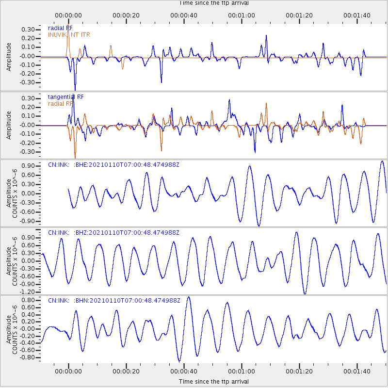
INK INUVIK, NT - Earthquake Result Viewer
*The percent match for this event was below the threshold and hence no stack was calculated.
| Earthquake location: |
Vanuatu Islands |
| Earthquake latitude/longitude: |
-16.0/167.9 |
| Earthquake time(UTC): |
2021/01/10 (010) 06:48:20 GMT |
| Earthquake Depth: |
160 km |
| Earthquake Magnitude: |
6.1 mww |
| Earthquake Catalog/Contributor: |
NEIC PDE/us |
|
| Network: |
CN Canadian National Seismograph Network |
| Station: |
INK INUVIK, NT |
| Lat/Lon: |
68.31 N/133.53 W |
| Elevation: |
44 m |
|
| Distance: |
93.9 deg |
| Az: |
18.552 deg |
| Baz: |
235.373 deg |
| Ray Param: |
$rayparam |
*The percent match for this event was below the threshold and hence was not used in the summary stack. |
|
| Radial Match: |
76.8192 % |
| Radial Bump: |
400 |
| Transverse Match: |
78.93509 % |
| Transverse Bump: |
400 |
| SOD ConfigId: |
23341671 |
| Insert Time: |
2021-01-24 07:54:56.598 +0000 |
| GWidth: |
2.5 |
| Max Bumps: |
400 |
| Tol: |
0.001 |
|
Signal To Noise
| Channel | StoN | STA | LTA |
| CN:INK: :BHZ:20210110T07:00:48.474988Z | 1.6490172 | 6.121052E-7 | 3.7119398E-7 |
| CN:INK: :BHN:20210110T07:00:48.474988Z | 1.0893394 | 3.2987404E-7 | 3.0282027E-7 |
| CN:INK: :BHE:20210110T07:00:48.474988Z | 1.6380682 | 3.8225681E-7 | 2.3335829E-7 |
| Arrivals |
| Ps | |
| PpPs | |
| PsPs/PpSs | |


