You are here: Home > Network List > IU - Global Seismograph Network (GSN - IRIS/USGS) Stations List
> Station WVT Waverly, Tennessee, USA > Earthquake Result Viewer
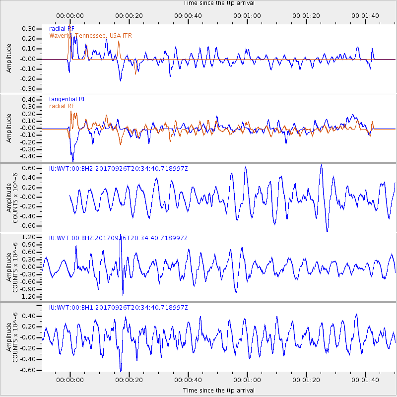
WVT Waverly, Tennessee, USA - Earthquake Result Viewer
*The percent match for this event was below the threshold and hence no stack was calculated.
| Earthquake location: |
Near East Coast Of Honshu, Japan |
| Earthquake latitude/longitude: |
40.3/142.4 |
| Earthquake time(UTC): |
2017/09/26 (269) 20:22:11 GMT |
| Earthquake Depth: |
36 km |
| Earthquake Magnitude: |
5.8 Mww |
| Earthquake Catalog/Contributor: |
NEIC PDE/us |
|
| Network: |
IU Global Seismograph Network (GSN - IRIS/USGS) |
| Station: |
WVT Waverly, Tennessee, USA |
| Lat/Lon: |
36.13 N/87.83 W |
| Elevation: |
170 m |
|
| Distance: |
91.0 deg |
| Az: |
38.491 deg |
| Baz: |
323.998 deg |
| Ray Param: |
$rayparam |
*The percent match for this event was below the threshold and hence was not used in the summary stack. |
|
| Radial Match: |
58.545555 % |
| Radial Bump: |
400 |
| Transverse Match: |
63.293106 % |
| Transverse Bump: |
400 |
| SOD ConfigId: |
2364251 |
| Insert Time: |
2017-10-10 20:32:00.114 +0000 |
| GWidth: |
2.5 |
| Max Bumps: |
400 |
| Tol: |
0.001 |
|
Signal To Noise
| Channel | StoN | STA | LTA |
| IU:WVT:00:BHZ:20170926T20:34:40.718997Z | 1.3346386 | 2.8574135E-7 | 2.1409642E-7 |
| IU:WVT:00:BH1:20170926T20:34:40.718997Z | 1.2600787 | 1.8731411E-7 | 1.4865272E-7 |
| IU:WVT:00:BH2:20170926T20:34:40.718997Z | 1.4225641 | 2.5316467E-7 | 1.7796361E-7 |
| Arrivals |
| Ps | |
| PpPs | |
| PsPs/PpSs | |


