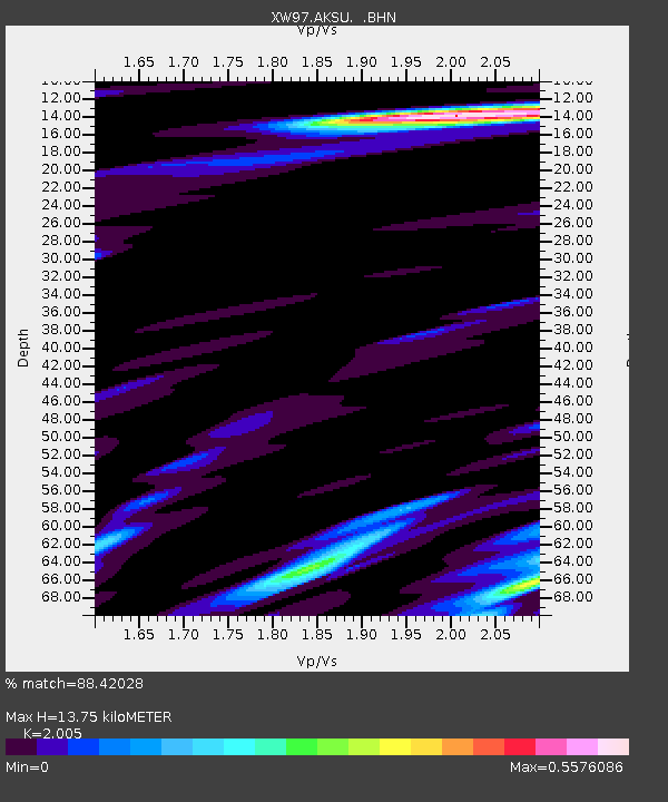
AKSU XW.AKSU - Earthquake Result Viewer
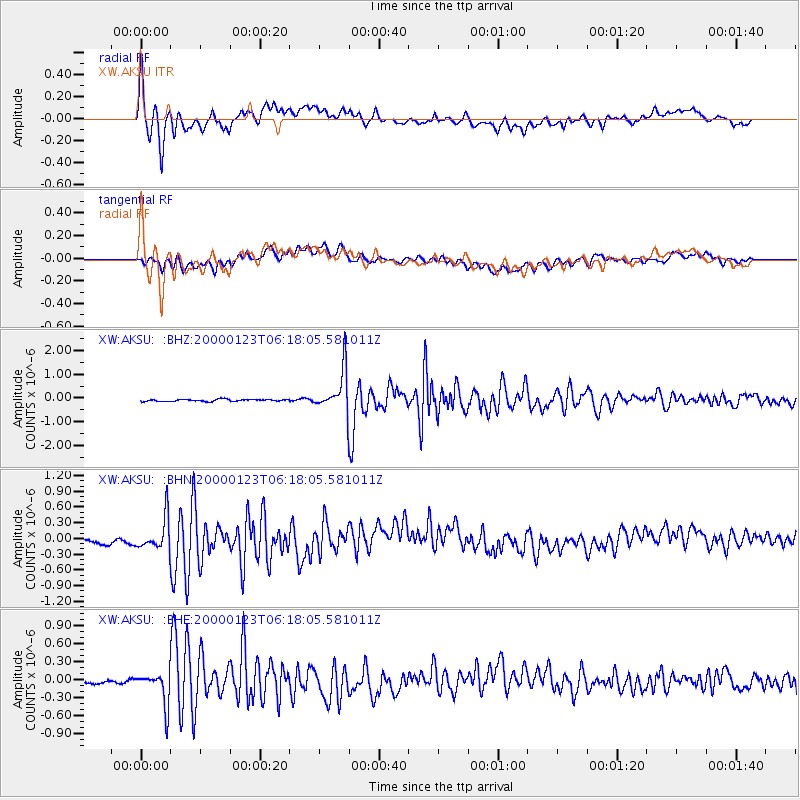
Earthquake location: Flores Sea
Earthquake latitude/longitude: -8.0/120.6
Earthquake time(UTC): 2000/01/23 (023) 06:08:24 GMT
Earthquake Depth: 47 km
Earthquake Magnitude: 5.7 MB, 5.2 MS, 5.8 MW, 5.7 MW
Earthquake Catalog/Contributor: WHDF/NEIC
Network: XW Tien Shan Continental Dynamics
Station: AKSU XW.AKSU
Lat/Lon: 41.14 N/80.11 E
Elevation: 1109 m
Distance: 61.4 deg
Az: 326.038 deg
Baz: 132.892 deg
Ray Param: 0.06079409
Estimated Moho Depth: 13.75 km
Estimated Crust Vp/Vs: 2.01
Assumed Crust Vp: 6.129 km/s
Estimated Crust Vs: 3.057 km/s
Estimated Crust Poisson's Ratio: 0.33
Radial Match: 88.42028 %
Radial Bump: 400
Transverse Match: 52.46231 %
Transverse Bump: 400
SOD ConfigId: 20082
Insert Time: 2010-02-26 15:14:46.740 +0000
GWidth: 2.5
Max Bumps: 400
Tol: 0.001

Signal To Noise

ChannelStoNSTALTA
XW:AKSU: :BHN:20000123T06:18:05.581011Z1.68512513.1991362E-71.8984562E-7
XW:AKSU: :BHE:20000123T06:18:05.581011Z3.30497742.7257957E-78.247547E-8
XW:AKSU: :BHZ:20000123T06:18:05.581011Z20.407858.7972245E-74.3107057E-8
Arrivals
Ps2.3 SECOND
PpPs6.5 SECOND
PsPs/PpSs8.8 SECOND