You are here: Home > Network List > GE - GEOFON Stations List
> Station SUW GEOFON Station Suwalki, Poland > Earthquake Result Viewer
SUW GEOFON Station Suwalki, Poland - Earthquake Result Viewer
| Earthquake location: |
Sea Of Okhotsk |
| Earthquake latitude/longitude: |
53.9/152.9 |
| Earthquake time(UTC): |
2008/07/05 (187) 02:12:04 GMT |
| Earthquake Depth: |
633 km |
| Earthquake Magnitude: |
6.8 MB, 7.7 MW, 7.7 MW |
| Earthquake Catalog/Contributor: |
WHDF/NEIC |
|
| Network: |
GE GEOFON |
| Station: |
SUW GEOFON Station Suwalki, Poland |
| Lat/Lon: |
54.01 N/23.18 E |
| Elevation: |
152 m |
|
| Distance: |
64.7 deg |
| Az: |
329.852 deg |
| Baz: |
30.252 deg |
| Ray Param: |
0.05633418 |
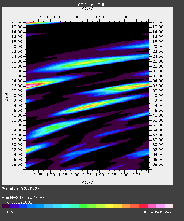
| Estimated Moho Depth: |
36.0 km |
| Estimated Crust Vp/Vs: |
1.60 |
| Assumed Crust Vp: |
6.53 km/s |
| Estimated Crust Vs: |
4.075 km/s |
| Estimated Crust Poisson's Ratio: |
0.18 |
|
| Radial Match: |
96.89167 % |
| Radial Bump: |
400 |
| Transverse Match: |
94.50719 % |
| Transverse Bump: |
400 |
| SOD ConfigId: |
2504 |
| Insert Time: |
2010-03-09 04:43:08.509 +0000 |
| GWidth: |
2.5 |
| Max Bumps: |
400 |
| Tol: |
0.001 |
|

Signal To Noise
| Channel | StoN | STA | LTA |
| GE:SUW: :BHN:20080705T02:21:11.318013Z | 77.68026 | 4.385476E-5 | 5.6455474E-7 |
| GE:SUW: :BHE:20080705T02:21:11.318013Z | 63.794197 | 2.3225244E-5 | 3.6406516E-7 |
| GE:SUW: :BHZ:20080705T02:21:11.318013Z | 37.701744 | 7.591045E-6 | 2.0134466E-7 |
| Arrivals |
| Ps | 3.5 SECOND |
| PpPs | 14 SECOND |
| PsPs/PpSs | 17 SECOND |


