You are here: Home > Network List > IW - Intermountain West Stations List
> Station IMW Indian Meadow, Wyoming, USA > Earthquake Result Viewer
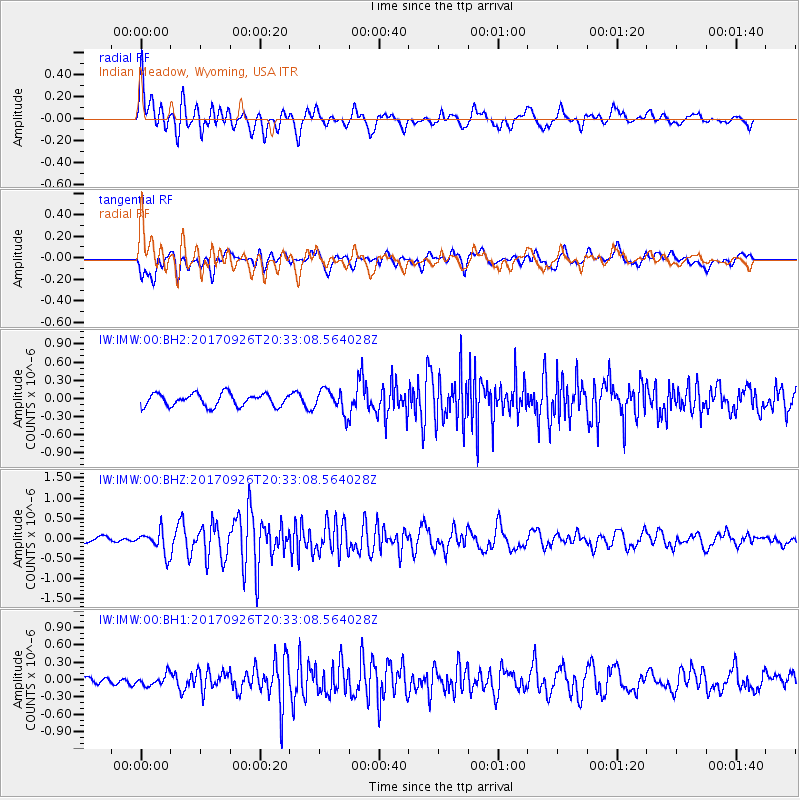
IMW Indian Meadow, Wyoming, USA - Earthquake Result Viewer
*The percent match for this event was below the threshold and hence no stack was calculated.
| Earthquake location: |
Near East Coast Of Honshu, Japan |
| Earthquake latitude/longitude: |
40.3/142.4 |
| Earthquake time(UTC): |
2017/09/26 (269) 20:22:11 GMT |
| Earthquake Depth: |
36 km |
| Earthquake Magnitude: |
5.8 Mww |
| Earthquake Catalog/Contributor: |
NEIC PDE/us |
|
| Network: |
IW Intermountain West |
| Station: |
IMW Indian Meadow, Wyoming, USA |
| Lat/Lon: |
43.90 N/110.94 W |
| Elevation: |
2646 m |
|
| Distance: |
73.3 deg |
| Az: |
46.301 deg |
| Baz: |
310.124 deg |
| Ray Param: |
$rayparam |
*The percent match for this event was below the threshold and hence was not used in the summary stack. |
|
| Radial Match: |
73.71608 % |
| Radial Bump: |
400 |
| Transverse Match: |
63.63829 % |
| Transverse Bump: |
400 |
| SOD ConfigId: |
2364251 |
| Insert Time: |
2017-10-10 20:32:19.316 +0000 |
| GWidth: |
2.5 |
| Max Bumps: |
400 |
| Tol: |
0.001 |
|
Signal To Noise
| Channel | StoN | STA | LTA |
| IW:IMW:00:BHZ:20170926T20:33:08.564028Z | 3.4008408 | 2.8665588E-7 | 8.42897E-8 |
| IW:IMW:00:BH1:20170926T20:33:08.564028Z | 1.0209048 | 9.332611E-8 | 9.141509E-8 |
| IW:IMW:00:BH2:20170926T20:33:08.564028Z | 1.8456507 | 1.917186E-7 | 1.03875884E-7 |
| Arrivals |
| Ps | |
| PpPs | |
| PsPs/PpSs | |


