You are here: Home > Network List > GO - National Seismic Network of Georgia Stations List
> Station TBLG Delisi, Georgia > Earthquake Result Viewer
TBLG Delisi, Georgia - Earthquake Result Viewer

| Earthquake location: |
Flores Sea |
| Earthquake latitude/longitude: |
-7.2/120.5 |
| Earthquake time(UTC): |
2021/01/11 (011) 01:20:38 GMT |
| Earthquake Depth: |
618 km |
| Earthquake Magnitude: |
5.6 mww |
| Earthquake Catalog/Contributor: |
NEIC PDE/us |
|
| Network: |
GO National Seismic Network of Georgia |
| Station: |
TBLG Delisi, Georgia |
| Lat/Lon: |
41.73 N/44.74 E |
| Elevation: |
510 m |
|
| Distance: |
84.3 deg |
| Az: |
313.195 deg |
| Baz: |
104.912 deg |
| Ray Param: |
0.043772787 |
| Estimated Moho Depth: |
29.25 km |
| Estimated Crust Vp/Vs: |
1.63 |
| Assumed Crust Vp: |
6.291 km/s |
| Estimated Crust Vs: |
3.848 km/s |
| Estimated Crust Poisson's Ratio: |
0.20 |
|
| Radial Match: |
82.67479 % |
| Radial Bump: |
400 |
| Transverse Match: |
63.146187 % |
| Transverse Bump: |
400 |
| SOD ConfigId: |
23341671 |
| Insert Time: |
2021-01-25 02:24:10.561 +0000 |
| GWidth: |
2.5 |
| Max Bumps: |
400 |
| Tol: |
0.001 |
|
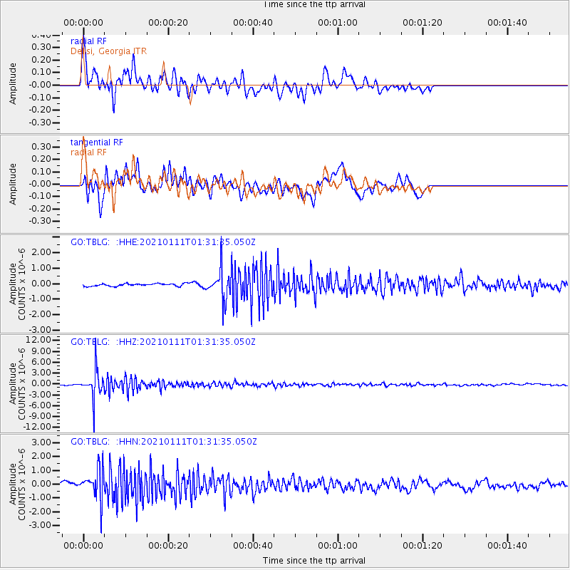
Signal To Noise
| Channel | StoN | STA | LTA |
| GO:TBLG: :HHZ:20210111T01:31:35.050Z | 27.044176 | 3.8127837E-6 | 1.4098353E-7 |
| GO:TBLG: :HHN:20210111T01:31:35.050Z | 6.026331 | 1.0901495E-6 | 1.8089771E-7 |
| GO:TBLG: :HHE:20210111T01:31:35.050Z | 11.93357 | 9.4731746E-7 | 7.938257E-8 |
| Arrivals |
| Ps | 3.0 SECOND |
| PpPs | 12 SECOND |
| PsPs/PpSs | 15 SECOND |


