You are here: Home > Network List > PF - Volcanologic Network of Piton de Fournaise-OVPF Stations List
> Station GPS Grandes Pentes Sud > Earthquake Result Viewer
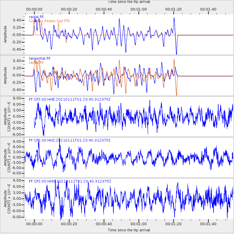
GPS Grandes Pentes Sud - Earthquake Result Viewer
*The percent match for this event was below the threshold and hence no stack was calculated.
| Earthquake location: |
Flores Sea |
| Earthquake latitude/longitude: |
-7.2/120.5 |
| Earthquake time(UTC): |
2021/01/11 (011) 01:20:38 GMT |
| Earthquake Depth: |
618 km |
| Earthquake Magnitude: |
5.6 mww |
| Earthquake Catalog/Contributor: |
NEIC PDE/us |
|
| Network: |
PF Volcanologic Network of Piton de Fournaise-OVPF |
| Station: |
GPS Grandes Pentes Sud |
| Lat/Lon: |
21.27 S/55.76 E |
| Elevation: |
1004 m |
|
| Distance: |
63.9 deg |
| Az: |
249.943 deg |
| Baz: |
87.692 deg |
| Ray Param: |
$rayparam |
*The percent match for this event was below the threshold and hence was not used in the summary stack. |
|
| Radial Match: |
71.70126 % |
| Radial Bump: |
400 |
| Transverse Match: |
65.34741 % |
| Transverse Bump: |
400 |
| SOD ConfigId: |
23341671 |
| Insert Time: |
2021-01-25 02:26:27.415 +0000 |
| GWidth: |
2.5 |
| Max Bumps: |
400 |
| Tol: |
0.001 |
|
Signal To Noise
| Channel | StoN | STA | LTA |
| PF:GPS:00:HHZ:20210111T01:29:40.912976Z | 2.1380353 | 3.7077564E-6 | 1.7341885E-6 |
| PF:GPS:00:HHN:20210111T01:29:40.912976Z | 1.1907678 | 2.7541546E-6 | 2.3129235E-6 |
| PF:GPS:00:HHE:20210111T01:29:40.912976Z | 0.8403786 | 2.6449995E-6 | 3.1473905E-6 |
| Arrivals |
| Ps | |
| PpPs | |
| PsPs/PpSs | |


