You are here: Home > Network List > AK - Alaska Regional Network Stations List
> Station K27K Chicken, AK, USA > Earthquake Result Viewer
K27K Chicken, AK, USA - Earthquake Result Viewer
| Earthquake location: |
Russia-Mongolia Border Region |
| Earthquake latitude/longitude: |
51.2/100.4 |
| Earthquake time(UTC): |
2021/01/11 (011) 21:32:58 GMT |
| Earthquake Depth: |
10 km |
| Earthquake Magnitude: |
6.7 mww |
| Earthquake Catalog/Contributor: |
NEIC PDE/us |
|
| Network: |
AK Alaska Regional Network |
| Station: |
K27K Chicken, AK, USA |
| Lat/Lon: |
64.03 N/142.08 W |
| Elevation: |
732 m |
|
| Distance: |
55.2 deg |
| Az: |
28.398 deg |
| Baz: |
317.234 deg |
| Ray Param: |
0.06494427 |
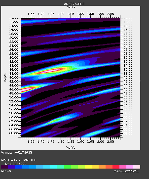
| Estimated Moho Depth: |
36.5 km |
| Estimated Crust Vp/Vs: |
1.75 |
| Assumed Crust Vp: |
6.566 km/s |
| Estimated Crust Vs: |
3.757 km/s |
| Estimated Crust Poisson's Ratio: |
0.26 |
|
| Radial Match: |
91.78935 % |
| Radial Bump: |
384 |
| Transverse Match: |
75.59085 % |
| Transverse Bump: |
400 |
| SOD ConfigId: |
23341671 |
| Insert Time: |
2021-01-25 22:36:20.637 +0000 |
| GWidth: |
2.5 |
| Max Bumps: |
400 |
| Tol: |
0.001 |
|

Signal To Noise
| Channel | StoN | STA | LTA |
| AK:K27K: :BHZ:20210111T21:42:00.859992Z | 2.487113 | 1.5348119E-6 | 6.171058E-7 |
| AK:K27K: :BHN:20210111T21:42:00.859992Z | 1.7440983 | 5.233802E-7 | 3.000864E-7 |
| AK:K27K: :BHE:20210111T21:42:00.859992Z | 3.4245713 | 9.855058E-7 | 2.8777492E-7 |
| Arrivals |
| Ps | 4.4 SECOND |
| PpPs | 14 SECOND |
| PsPs/PpSs | 19 SECOND |


