You are here: Home > Network List > AK - Alaska Regional Network Stations List
> Station PPLA Purkeypile > Earthquake Result Viewer
PPLA Purkeypile - Earthquake Result Viewer
| Earthquake location: |
Russia-Mongolia Border Region |
| Earthquake latitude/longitude: |
51.2/100.4 |
| Earthquake time(UTC): |
2021/01/11 (011) 21:32:58 GMT |
| Earthquake Depth: |
10 km |
| Earthquake Magnitude: |
6.7 mww |
| Earthquake Catalog/Contributor: |
NEIC PDE/us |
|
| Network: |
AK Alaska Regional Network |
| Station: |
PPLA Purkeypile |
| Lat/Lon: |
62.90 N/152.19 W |
| Elevation: |
1519 m |
|
| Distance: |
52.7 deg |
| Az: |
33.311 deg |
| Baz: |
311.086 deg |
| Ray Param: |
0.0665634 |
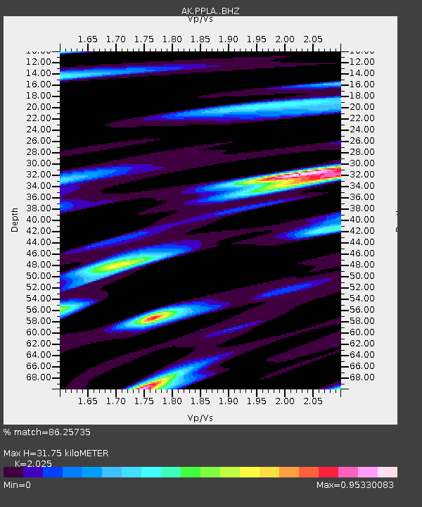
| Estimated Moho Depth: |
31.75 km |
| Estimated Crust Vp/Vs: |
2.03 |
| Assumed Crust Vp: |
6.566 km/s |
| Estimated Crust Vs: |
3.243 km/s |
| Estimated Crust Poisson's Ratio: |
0.34 |
|
| Radial Match: |
86.25735 % |
| Radial Bump: |
400 |
| Transverse Match: |
75.15686 % |
| Transverse Bump: |
400 |
| SOD ConfigId: |
23341671 |
| Insert Time: |
2021-01-25 22:36:52.616 +0000 |
| GWidth: |
2.5 |
| Max Bumps: |
400 |
| Tol: |
0.001 |
|

Signal To Noise
| Channel | StoN | STA | LTA |
| AK:PPLA: :BHZ:20210111T21:41:42.867987Z | 2.9491115 | 2.3716048E-6 | 8.04176E-7 |
| AK:PPLA: :BHN:20210111T21:41:42.867987Z | 0.8016547 | 8.68043E-7 | 1.0828142E-6 |
| AK:PPLA: :BHE:20210111T21:41:42.867987Z | 1.8481848 | 1.3583463E-6 | 7.349623E-7 |
| Arrivals |
| Ps | 5.2 SECOND |
| PpPs | 14 SECOND |
| PsPs/PpSs | 19 SECOND |


