You are here: Home > Network List > TX - Texas Seismological Network Stations List
> Station WTFS Witchita Falls > Earthquake Result Viewer
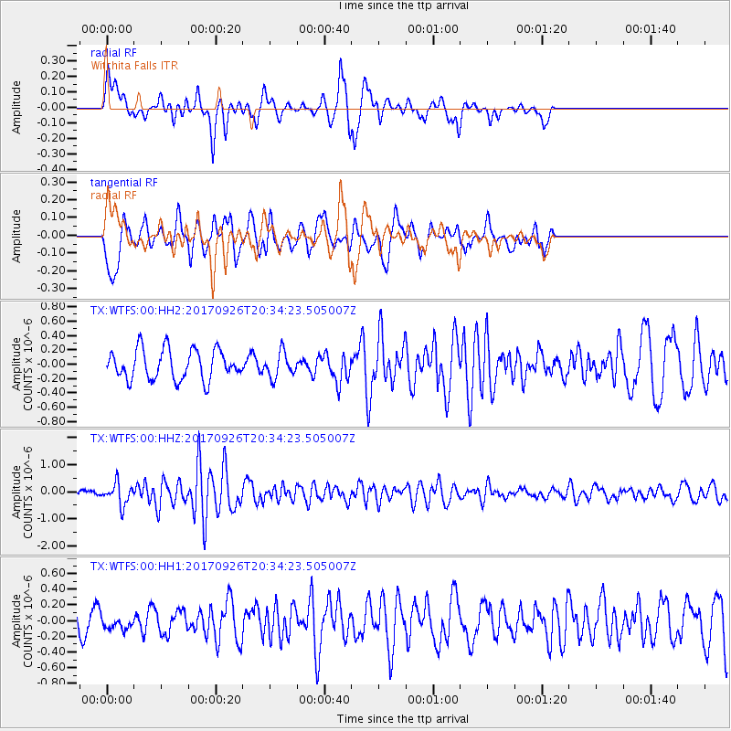
WTFS Witchita Falls - Earthquake Result Viewer
*The percent match for this event was below the threshold and hence no stack was calculated.
| Earthquake location: |
Near East Coast Of Honshu, Japan |
| Earthquake latitude/longitude: |
40.3/142.4 |
| Earthquake time(UTC): |
2017/09/26 (269) 20:22:11 GMT |
| Earthquake Depth: |
36 km |
| Earthquake Magnitude: |
5.8 Mww |
| Earthquake Catalog/Contributor: |
NEIC PDE/us |
|
| Network: |
TX Texas Seismological Network |
| Station: |
WTFS Witchita Falls |
| Lat/Lon: |
33.77 N/98.46 W |
| Elevation: |
277 m |
|
| Distance: |
87.3 deg |
| Az: |
46.757 deg |
| Baz: |
318.041 deg |
| Ray Param: |
$rayparam |
*The percent match for this event was below the threshold and hence was not used in the summary stack. |
|
| Radial Match: |
43.220722 % |
| Radial Bump: |
317 |
| Transverse Match: |
61.597015 % |
| Transverse Bump: |
400 |
| SOD ConfigId: |
2364251 |
| Insert Time: |
2017-10-10 20:36:07.419 +0000 |
| GWidth: |
2.5 |
| Max Bumps: |
400 |
| Tol: |
0.001 |
|
Signal To Noise
| Channel | StoN | STA | LTA |
| TX:WTFS:00:HHZ:20170926T20:34:23.505007Z | 2.8833995 | 4.061291E-7 | 1.4085079E-7 |
| TX:WTFS:00:HH1:20170926T20:34:23.505007Z | 0.37281385 | 7.428005E-8 | 1.9924165E-7 |
| TX:WTFS:00:HH2:20170926T20:34:23.505007Z | 0.843506 | 1.7527714E-7 | 2.0779596E-7 |
| Arrivals |
| Ps | |
| PpPs | |
| PsPs/PpSs | |


