You are here: Home > Network List > AK - Alaska Regional Network Stations List
> Station F18K Selawik, AK, USA > Earthquake Result Viewer
F18K Selawik, AK, USA - Earthquake Result Viewer
| Earthquake location: |
Russia-Mongolia Border Region |
| Earthquake latitude/longitude: |
51.2/100.4 |
| Earthquake time(UTC): |
2021/01/11 (011) 21:32:58 GMT |
| Earthquake Depth: |
10 km |
| Earthquake Magnitude: |
6.7 mww |
| Earthquake Catalog/Contributor: |
NEIC PDE/us |
|
| Network: |
AK Alaska Regional Network |
| Station: |
F18K Selawik, AK, USA |
| Lat/Lon: |
66.60 N/159.65 W |
| Elevation: |
27 m |
|
| Distance: |
47.9 deg |
| Az: |
31.995 deg |
| Baz: |
303.497 deg |
| Ray Param: |
0.06968423 |
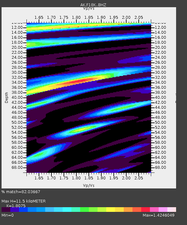
| Estimated Moho Depth: |
11.5 km |
| Estimated Crust Vp/Vs: |
1.81 |
| Assumed Crust Vp: |
6.577 km/s |
| Estimated Crust Vs: |
3.639 km/s |
| Estimated Crust Poisson's Ratio: |
0.28 |
|
| Radial Match: |
82.03667 % |
| Radial Bump: |
400 |
| Transverse Match: |
66.87311 % |
| Transverse Bump: |
400 |
| SOD ConfigId: |
23341671 |
| Insert Time: |
2021-01-25 22:38:21.600 +0000 |
| GWidth: |
2.5 |
| Max Bumps: |
400 |
| Tol: |
0.001 |
|

Signal To Noise
| Channel | StoN | STA | LTA |
| AK:F18K: :BHZ:20210111T21:41:06.63999Z | 4.273432 | 2.3283858E-6 | 5.448515E-7 |
| AK:F18K: :BHN:20210111T21:41:06.63999Z | 1.8050759 | 7.7915644E-7 | 4.3164746E-7 |
| AK:F18K: :BHE:20210111T21:41:06.63999Z | 1.7815585 | 1.3993807E-6 | 7.854812E-7 |
| Arrivals |
| Ps | 1.5 SECOND |
| PpPs | 4.6 SECOND |
| PsPs/PpSs | 6.1 SECOND |


