You are here: Home > Network List > C0 - Colorado Geological Survey Seismic Network Stations List
> Station HAYD Hayden Colorado > Earthquake Result Viewer
HAYD Hayden Colorado - Earthquake Result Viewer
| Earthquake location: |
Russia-Mongolia Border Region |
| Earthquake latitude/longitude: |
51.2/100.4 |
| Earthquake time(UTC): |
2021/01/11 (011) 21:32:58 GMT |
| Earthquake Depth: |
10 km |
| Earthquake Magnitude: |
6.7 mww |
| Earthquake Catalog/Contributor: |
NEIC PDE/us |
|
| Network: |
C0 Colorado Geological Survey Seismic Network |
| Station: |
HAYD Hayden Colorado |
| Lat/Lon: |
40.53 N/107.27 W |
| Elevation: |
2202 m |
|
| Distance: |
85.5 deg |
| Az: |
20.822 deg |
| Baz: |
342.953 deg |
| Ray Param: |
0.044751912 |
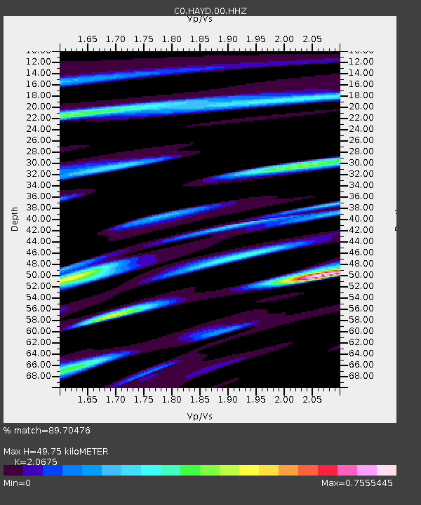
| Estimated Moho Depth: |
49.75 km |
| Estimated Crust Vp/Vs: |
2.07 |
| Assumed Crust Vp: |
6.159 km/s |
| Estimated Crust Vs: |
2.979 km/s |
| Estimated Crust Poisson's Ratio: |
0.35 |
|
| Radial Match: |
89.70476 % |
| Radial Bump: |
400 |
| Transverse Match: |
71.05876 % |
| Transverse Bump: |
400 |
| SOD ConfigId: |
23341671 |
| Insert Time: |
2021-01-25 22:41:02.399 +0000 |
| GWidth: |
2.5 |
| Max Bumps: |
400 |
| Tol: |
0.001 |
|

Signal To Noise
| Channel | StoN | STA | LTA |
| C0:HAYD:00:HHZ:20210111T21:45:05.229987Z | 4.1108036 | 8.55604E-7 | 2.0813548E-7 |
| C0:HAYD:00:HHN:20210111T21:45:05.229987Z | 3.6168895 | 4.5113316E-7 | 1.247296E-7 |
| C0:HAYD:00:HHE:20210111T21:45:05.229987Z | 0.7444949 | 1.7118316E-7 | 2.2993194E-7 |
| Arrivals |
| Ps | 8.8 SECOND |
| PpPs | 24 SECOND |
| PsPs/PpSs | 33 SECOND |


