You are here: Home > Network List > US - United States National Seismic Network Stations List
> Station HAWA Hanford, Washington, USA > Earthquake Result Viewer
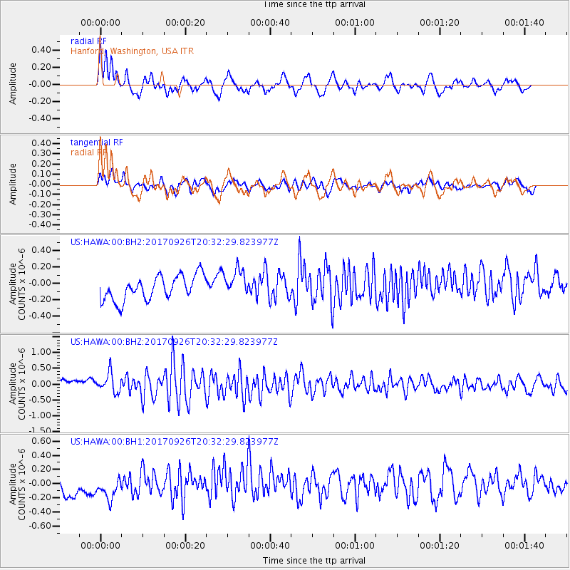
HAWA Hanford, Washington, USA - Earthquake Result Viewer
*The percent match for this event was below the threshold and hence no stack was calculated.
| Earthquake location: |
Near East Coast Of Honshu, Japan |
| Earthquake latitude/longitude: |
40.3/142.4 |
| Earthquake time(UTC): |
2017/09/26 (269) 20:22:11 GMT |
| Earthquake Depth: |
36 km |
| Earthquake Magnitude: |
5.8 Mww |
| Earthquake Catalog/Contributor: |
NEIC PDE/us |
|
| Network: |
US United States National Seismic Network |
| Station: |
HAWA Hanford, Washington, USA |
| Lat/Lon: |
46.39 N/119.53 W |
| Elevation: |
364 m |
|
| Distance: |
67.0 deg |
| Az: |
48.122 deg |
| Baz: |
304.665 deg |
| Ray Param: |
$rayparam |
*The percent match for this event was below the threshold and hence was not used in the summary stack. |
|
| Radial Match: |
72.17976 % |
| Radial Bump: |
400 |
| Transverse Match: |
52.732025 % |
| Transverse Bump: |
400 |
| SOD ConfigId: |
2364251 |
| Insert Time: |
2017-10-10 20:37:14.738 +0000 |
| GWidth: |
2.5 |
| Max Bumps: |
400 |
| Tol: |
0.001 |
|
Signal To Noise
| Channel | StoN | STA | LTA |
| US:HAWA:00:BHZ:20170926T20:32:29.823977Z | 1.9773622 | 3.3087866E-7 | 1.6733337E-7 |
| US:HAWA:00:BH1:20170926T20:32:29.823977Z | 1.3064141 | 2.2836063E-7 | 1.7479957E-7 |
| US:HAWA:00:BH2:20170926T20:32:29.823977Z | 1.1148726 | 1.650119E-7 | 1.4800965E-7 |
| Arrivals |
| Ps | |
| PpPs | |
| PsPs/PpSs | |


